Fury and Hecla: Parry’s Formidable Arctic Exploration Sisters

On March 31st, 1827, Captain William Edward Parry took leave of his friends, relations, and his young wife Isabella. He boarded his beloved exploration vessel, HMS Hecla. After five expeditions searching for a Northwest Passage in the Canadian Arctic – four of which he was in overall command of – he was setting out for a different destination: The North Pole. Onboard Hecla were the latest contingent of a long line of British officers who would write their names on geographic features across both Arctic and Antarctic regions.1 His crew well-understood the hazards of polar exploration. On Parry’s last expedition Hecla’s sistership and exploration consort, HMS Fury, had been destroyed. Parry – an evangelical Christian – must have wondered, as he moved north along the English coast, if Providence and his continuing good fortune would keep them all safe on this new foray towards the top of the World.
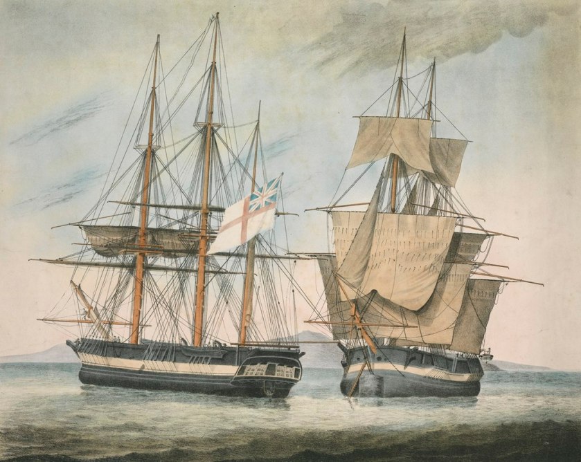
His Majesty’s Discovery ships, Fury and Hecla by Arthur Parsey (Artist & Engraver) Charles Joseph Hullmandel (Printer) in 1823. Both show “Parry scheme” modifications for Arctic service, with broadside armament and mortars removed, reinforced channels, and bow iceguards. credit: National Maritime Museum PAH9224.

Forty-five years elapsed from the Constantine Phipps North Pole Expedition until William Edward Parry’s 1819 Northwest Passage search again brought polar-modified bomb vessels back to the Arctic. The 1741 modifications to HMS Furnace had set a basic pattern for the reinforcing bomb vessels to participate in polar exploration missions. The Phipps’ North Pole attempt had introduced yet more innovations.2 However, the “Parry scheme” – the identical strengthening of two sisterships – HM Ships Hecla and Fury – is the most relevant precedent for the modifications of the final, and ill-fated bombs, HM Ships Terror and then Erebus.

Both Hecla and Fury were laid down in 1813, and completed at the very twilight of the Napoleonic Wars. The Hecla class was a slight enlargement of the Vesuvius class bomb vessels.3 They were 105′ / 32m long on the gundeck, 28.5′ /8.7m in maximum beam, and displaced about 375 tons.4 Like the previous exploration bombs Furnace, Racehorse, and Carcass, these two sisterships had participated in a military campaign in their intended role: Firing bombs or carcasses (incendiary shells) from their main armament of a 10” and 13″ mortars. Both had been members of Admiral Edward Pellew’s fleet during the Bombardment of Algiers, 27 August 1816. They, along with the other bomb vessels Beelzebub and Infernal, fired hundreds of shells into the defences, harbour, and city, and were present the next day when the Dey of Algiers capitulated.
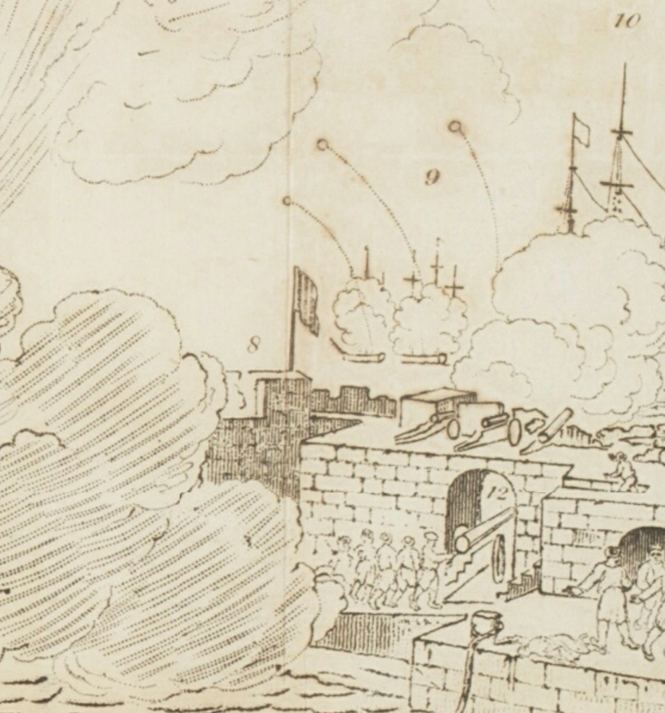
A detail of a panoramic illustration of the Bombardment of Algiers, showing Hecla, Fury and Belzebub firing bombs on a high trajectory. A section of the fortified harbour wall and a great gun are in the foreground. Panoramic views of various places : collection of pamphlets describing panoramas on exhibition in London, 1818 -1832 [detail of panoramic illustration] Credit: State Library of New South Wales DSM/791/PA1

Hecla’s first exposure to Arctic service involved conversion for a Northwest Passage expedition. This mission followed up on John Ross’s recent voyage, which had used two converted whaling ships, Isabella and Alexander, to revive the whole program of Admiralty polar exploration.5 Lieutenant William Edward Parry (who had commanded Alexander) would now make his own effort to solve the great cartographic mystery at the top of North America: was there a navigable passage from Baffin Bay through to the Western Arctic?6 Parry was also directed to try to resolve the cartographic confusion that John Ross’s mission had raised.7 His methodical approach to preparing for polar exploration involved thoughtful consideration of the unique environment his crews would operate in, an almost fanatical attention to technical details of the ships, equipment, and supplies, and careful planning for unanticipated situations.

Capt. William Edward Parry, Commander of the Polar Expeditions (on the print this is updated from 1819-1827). Credit: Credit: Library and Archives Canada, Acc. No. 1939-159-1.

Hecla was accompanied by HMS Griper (Matthew Liddon commanding). Griper was a gunbrig: a much smaller type that was about 85’/26m long on the gundeck and displaced only 180 tons. The pairing of a lead ship with a smaller consort had been a feature of prior expeditions. The reinforcement of the ships combined the best features of previous refits. Parry’s expedition made remarkable progress westwards into the uncharted Arctic Archipelago at the top of the North American landmass. The crews overwintered, in their carefully prepared and housed-over ships, in the midst of their discovery mission.8 This frozen pause, far north of the Arctic Circle, was a first for the Admiralty exploration program.

This image of Hecla on her first mission, housed over for overwintering at Melville Island with Griper nearby, is take from The frozen zone and its explorers; a comprehensive record of voyages, travels, discoveries, adventures and whale-fishing in the Arctic regions for one thousand years, an 1874 publication. Internet Archive Book Images, No restrictions, via Wikimedia Commons

Parry penetrated the Arctic as far west as Cape Providence at the southwestern tip of Melville Island (beyond 113° degrees longitude west of Greenwich). With the (brief) navigation season rapidly closing, he chose to winter at a suitable bay back along the southern coast. As the ice was setting in, they had to cut their way in to “Winter Harbour” using ice saws. Parry kept his ships safe and his crews relatively healthy during this 10-month period. He even continued the exploration mission overland by leading treks to survey the northern coast of Melville, where he discovered Hecla and Griper Bay. Early the next exploration season, he was turned back from further progress westwards by pack ice. The two ships arrived home to wild enthusiasm in October 1820.
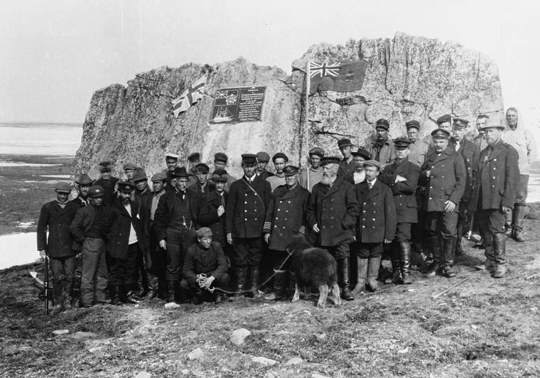
Captain Joseph-Elzéar Bernier and the crew of the CGS Arctic visit Parry’s rock at Winter Harbour, on 1 July 1909. They erected a commemorative plaque, alongside carvings made by Parry’s crew in 1819-1820, which would become important to Canadian sovereignty claims over the Arctic. This is now a National Historic Site of Canada. Credit: Library and Archives Canada C-001198

In preparation for Parry’s next mission to the Arctic, HMS Fury was reinforced to the same standard as Hecla, to become Parry’s lead ship in a new effort to locate a passage west. Hecla was commanded by George Francis Lyon. This dual refit, starting in late 1820 at Deptford Dockyard, represents the beginning of the classical age of the Admiralty’s program of strengthening ships for polar service: Here two sisterships were identically outfitted, to operate in tandem. In the event of the loss of one ship, both crews could be fully accommodated on the remaining ship.9 Parry described this important refit in detail in the published journal of his second expedition.10 In the wake of his first expedition, and frustrating experiences sailing in company with the slower Griper, he now rejected the convention that a lighter vessel, acting as a consort, could explore inshore waters more effectively than two evenly-matched ships. He emphasized that all inshore surveying could be completed by detached boat crews (who have the light vessels with minimal draft to best exploit inshore charting opportunities). He argued that ships of the same design could better survey a larger area (with independent charting of whole stretches of coastline a possibility). In order to ensure that sailing performance was as even as possible, he adopted what he called an “equalized rig” between ships. This went beyond merely ensuring that the three-masted barque rig of both ships was identical, because the fore and main masts were fitted with the exact same lengths of spar for a given sail type between both masts. This meant that four masts between two ships had the exact same spar dimensions for courses, topsails, and topgallant and studding sails – something that would greatly simplify repairs in case of damage to the top hamper.

The draught plans of the original Hecla class design of 1813 (upper ZAZ5687), and an internal arrangement plan of the modifications to Fury for the 1821 NW passage mission (lower ZAZ5696) © Crown copyright. National Maritime Museum, Greenwich, London

The original Admiralty plans, now preserved at the National Maritime Museum at Greenwich, show a more thorough conversion for Arctic service than any prior British vessel had undergone. In contrast to Racehorse and Carcass, Parry’s ships received a full weatherdeck, which united the quarterdeck, foc’sl, and the intervening space amidships. This decking enclosed a much larger internal space which could protect crews from foul weather and, more importantly, Arctic conditions. Fury and Hecla were the first bombs to be so heavily modified that no internal traces remained of their original mortar beds. They also were the first to have all gun-ports fully omitted (planked over). The fragile channels (where the shrouds connect down to the hull outboard of the rails) were filled in by ice chocks, as they had been on HMS Furnace in 1741. Massive timbers – Heavy bolsters and hooks – strengthened the bows. Parry’s ships had doubled planking on the exterior (which was thicker than what had been fitted to Hecla and Griper for the earlier mission). This ran all the way up to deck-level. The outer layer noticeably thickened at the waterline. Heavy iron strengthening bolted through the knees and keelson, spirketting (reinforced timbers) ran lengthwise, bolted into the frames at different levels. A full double layer of “footwailing” sheathed the area inside the frames of the lower hull (interior paneling in the hold which was laid diagonal for further strength). A sectional plan helps us further interpret the details of these massively strengthened vessels:

HMS Fury sectional plan, 1821 (ZAZ5700) © Crown copyright. National Maritime Museum, Greenwich, London

One of the most notable updates is the first use of diagonal deck planking on a discovery mission. This update can be seen in the uppermost layer of 3” thick decking, represented in the above plan as wider than the underlying fore-and-aft planking. The two layers made for a much stronger protective sheathing: 6” of wood, with a layer of waterproofing tar paper sandwiched in between. This strengthened decking was conventionally fastened to the underlying deck beams. The concept of diagonal decking appears to have been a recent novelty, and can be credited to a naval architect who was coming up with a whole system of new design elements to strengthen British warships: Sir Robert Seppings. Seppings had first installed diagonal decking to HMS Albion’s two gundecks in 1815. He had then arranged a comparative trial, where he had fitted it only to the port side decking of HMS Northumberland. This ship and its experimental deck were put to use from August to October 1815 to transport the deposed French Emperor, Napoleon Buonaparte, to his final exile on the island St. Helena.11 On Parry’s exploration ships, the diagonal sections flanked a central area of the deck, which had massively thickened decking – a full 6″ thick – running lengthwise. This reinforced and buttressed decking – visible today at the wreck sites of Erebus and Terror, created a structure of incredible solidity.12

A Sylvester warming oven (furnace) of an ingenious design circulated warm air to the newly-enclosed interior spaces by flues (it can be seen shaded blue in the second plan above). Relevant to air circulation and lighting below decks, Parry also noted in passing that his ships were fitted with “illuminators,” which, in this context, would appear to be a very early instance of the installation of Preston’s Patent illuminator (which also could be called a portable deck glass and ventilator).13
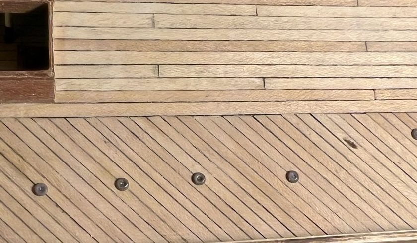
The reinforced diagonal decking and thicker central planks of a polar-modified bomb vessel looking from the main hatch forwards along the starboard side. Illuminators, which my research has established may have been fitted to Parry’s ships on his second polar expedition, and deck prisms also appear. (author’s photo of an incomplete model)

Parry’s second expedition in command (1821-1823) saw the ships overwinter first at Winter Island and then further north at Igloolik. This expedition had set yet another important polar precedent when the merchant vessel Nautilus was hired to transport some of the burden of coal and provisions across the Atlantic to Resolution Island (at the entrance to the Hudson Strait). Crew then discharged its cargo into the exploration vessels, to top up their supplies.14 No ice-free passage towards the west was located, but, in Foxe Basin, Parry did transit the Frozen Straits at the top of Southampton Island into Hudson’s Bay, finally proving the accuracy of Christopher Middleton’s 1742 surveying in HMS Furnace. Near Igloolik, he also discovered a frozen waterway stretching westwards out of the Basin, which he named Fury and Hecla Strait. Both his official publication and Lyon’s private journal (private yet officially approved to be published) include invaluable observations about local Inuit communities’ culture, social practices and daily life.15 All these decades later, Inuit communities on Igloolik Island and around the Melville Peninsula continue to preserve a rich oral tradition around the visit of Parry’s crews. In early 1823, Parry’s crews were beginning to show signs of the onset of that dreaded mariner’s disease: Scurvy. Hecla and Fury departed the Arctic in good condition for a safe return home. Despite Lyon’s remarkable ethnographic observations of Inuit community life, the actual cartographic results of the expedition could not compare to the incredible progress westwards of Parry’s first foray. Still, the public at home in Great Britain continued to be inspired by his exploration.
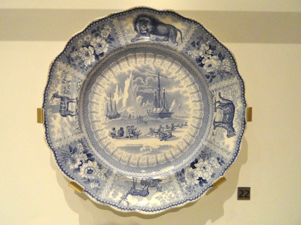
Parry’s Arctic expeditions led to widespread popular enthusiasm in Europe for depictions of Arctic adventures. A Staffordshire dish ca. 1835, shows an Arctic scene of Parry’s ships in the background, and Inuit community members with a sledge and dogs. This appears to be a inspired by a scene of Hecla and Griper at Winter Harbour, updated with events from later expeditions. Credit: Daderot, CC0, via Wikimedia Commons.

Parry immediately threw himself into the planning of yet another expedition. The discovery duo of Hecla and Fury would now look for a passage 500 km to the Northwest of Igloolik, down Prince Regent Inlet (a waterway which he had entered but not fully charted during his westward passage in 1819). Parry shifted back to Hecla. Henry Parkyns Hoppner (an experienced Arctic officer with service on all recent Parry-associated missions) took command of Fury.16 Departing England in May, 1824, the expedition again made use of a transport, the William Harris, which was unloaded at the Whalefish Islands, Greenland (now known as Kitsissut and Imerissoq). The exploration ships were delayed in crossing Baffin Bay, and had to winter at Port Bowen, on the eastern side of the Inlet. Officers and crew disliked the dreary winter site, and had misgivings about the mission to explore the Inlet.17 When finally released from the ice in late July 1825, the ships began navigating the western coast of North Somerset Land (Somerset Island’s insularity would not be proved until 1852), looking for some route to the west. It was along the dramatic cliffs of this coastline that disaster finally caught up with Parry’s crews.
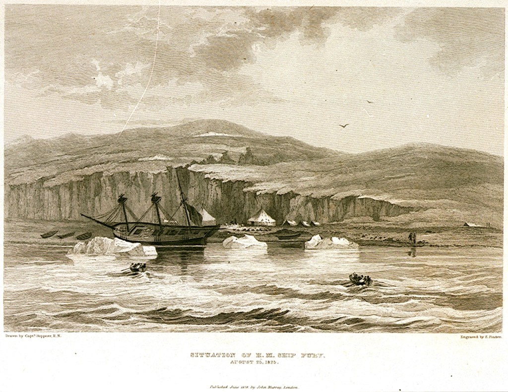
The appearance of HMS Fury on the day of her abandonment (taken from Parry’s Journal of his Third Expedition): Edward Francis Finden (engraver); Hoppner, Capt (artist); Murray, John (publisher), Public domain, via Wikimedia Commons

On the first of August, Fury and Hecla were both damaged by being nipped by ice as it crowded close in to the shores of Somerset Island. Unbeknownst to Parry, Fury was more severely wounded, and began taking on water at a prodigious rate. By the time Hoppner was able to report in, a third of the entire crew were required to work all four pumps just to keep the vessel afloat.18 A careful examination showed that, despite the phenomenal strengthening of the hull as noted above, the basic skeleton of the ship had been seriously damaged: Fury’s forefoot and sternpost were both mauled, and areas of the keel were effectively shattered.19 Parry’s published journal of the expedition relates the episodes of a worsening situation over the next week: Exhausting efforts to find a safe location to shelter the damaged vessel from further ice damage and unload her, to try and repair the hull, eventually failed when ice again crowded inshore and bodily heaved the ship up into the shallows of the beach. This further damaged the bilge areas on August 25th. Parry, returning onboard his former command, recognized the ship was doomed. He allowed Hoppner and his senior staff to carefully assess the ship. The verdict from Fury’s officers was clear: it was time to abandon their vessel and press on.20 A storage depot was created at Fury Beach, with anchors, anchor chains, spars, ships boats, and a vast supply of coal and provisions.21 Given the state of crowding and the reduction in provisions on Hecla, Parry turned aside from further exploration of the Inlet and hastened back to England. He concluded his official account of the protracted destruction of the Fury by stating “…it will be plain that an occurrence of this nature was at all times rather to be expected than otherwise, and that the only real cause for wonder has been our long exemption from such a catastrophe.”22

Remarkably, given the hazards of exploration and the amount of time he had been away from his home on these successive missions, Parry, newly-married, opted to lead one more Arctic expedition. The 1827 mission would see Hecla ordered towards a higher latitude than she had ever navigated to. Parry went from his old quest to complete a Northwest Passage to a mission aimed at the North Pole. This would revisit the site of both Constantine Phipps’ 1773 expedition, and the recent David Buchan and John Franklin 1818 journey towards the Pole: the Svalbard archipelago. The overall plan had actually been thought up by Franklin. John Barrow, Second Secretary at the Admiralty, forwarded it on to Franklin’s friend Parry.23 This time, his venerable exploration vessel would serve as a base ship for a further effort to push north, by carrying up two specially-constructed boats (named Enterprise and Endeavour). The 20′ long boats were fitted with conspicuous steel runners that reached down to the ice from the bilges, and could also be moved on wheels. They were ingeniously fortified, double-planked, and protected by inner layers of felt and Mackintosh waterproof canvas. Their design had been the result of a collaboration of expert naval architects Henry Peake and Oliver Lang.24 After Hecla reached Treurenberg Bay (Sorgfjorden), the two boat crews, commanded by Parry and James Clark Ross, John Ross’s nephew, sledged northwards from Hakluyt’s Headland on pack ice, in difficult conditions.25 Where the plan had envisioned a rapid sledge up to the Pole over smooth expanses of pack ice, the crews encountered a torturous, broken landscape. They reached a furthest north record of 82° 45′ before turning back, exhaused, for the shelter of their ship.26
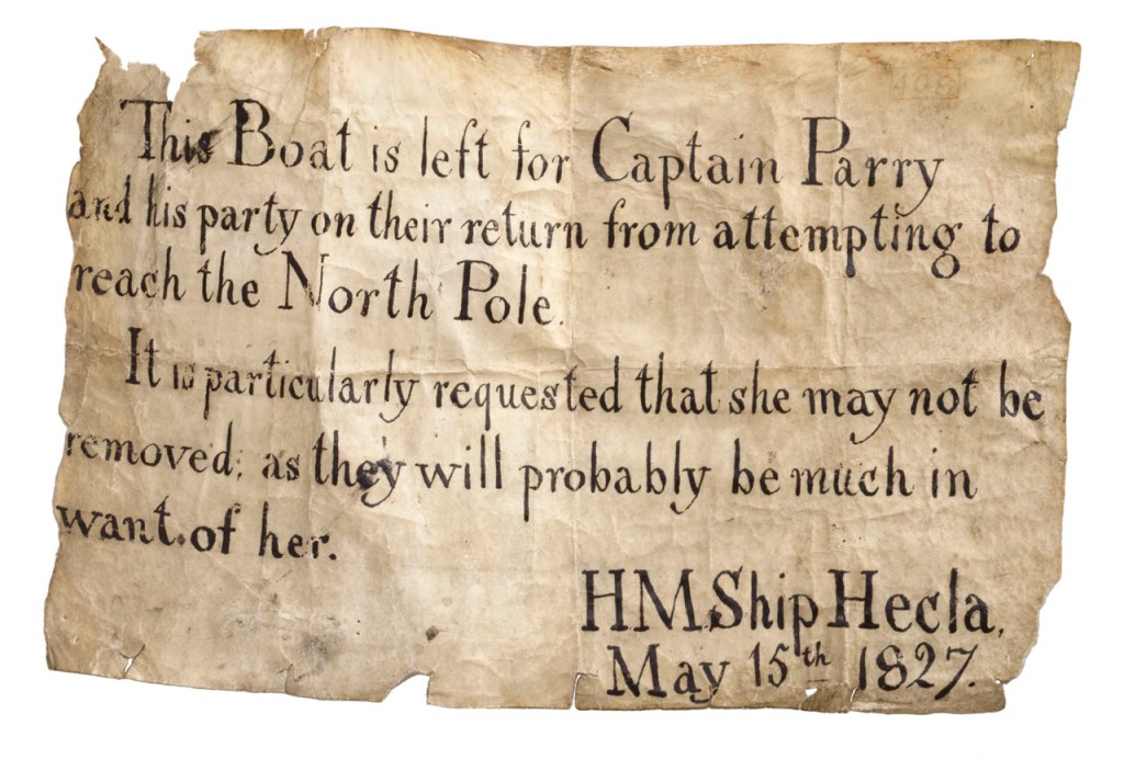
A note left by Parry’s crew, remaining with Hecla, to ensure that no one else absconded with a depot boat left to assist with the return from their polar mission. Credit: National Maritime Museum, Greenwich, London, Royal United Service Institution Collection (AAA3957)

And with her safe return to England from yet another record-setting mission – a highest north latitude that would stand for fifty years – Hecla reached the end of her Arctic exploration career. She was converted to the complimentary role of survey ship (to chart temperate waters, like several of the other surviving bomb vessels), and worked along the coasts of West Africa. Sold out of naval service in 1831, she was first used as a general cargo vessel and then converted to become a whaling ship for the 1835 season. Lloyd’s Register (LR) Foundation Archivist Max Wilson has located important documents to track the interesting history of Hecla’s commercial service. As Wilson notes: “Ironically Hecla was to hunt in the exact area she had opened up to whaling and explored in 1819.”27 She continued to endure Arctic punishment on annual whaling journeys to the familiar waters of the Davis Strait until she was wrecked there in 1840.28 Like her lost sister Fury, Hecla’s final resting spot has not yet been located.

With popular enthusiasm for exploration sustained by the published accounts of Parry’s exploits, the Admiralty turned to other modified bomb vessels to continue the exploration of polar regions. In late 1835, even as Hecla continued plying northern waters, there was a sudden need to rescue the crews of some of her fellow whaling ships: A dozen ships had become trapped in the pack ice of the Davis Strait. A slightly smaller, older bomb vessel, laid up at Portsmouth, was rushed into refit: HMS Terror.29 The scene was now set for the final conversions of the bomb vessel type to polar exploration ships.

This concludes our series of blog posts exploring the history of every bomb vessel that was converted to a polar discovery ship: HM Ships Furnace, Racehorse and Carcass, Hecla and Fury, Erebus and Terror.

Click for Endnotes
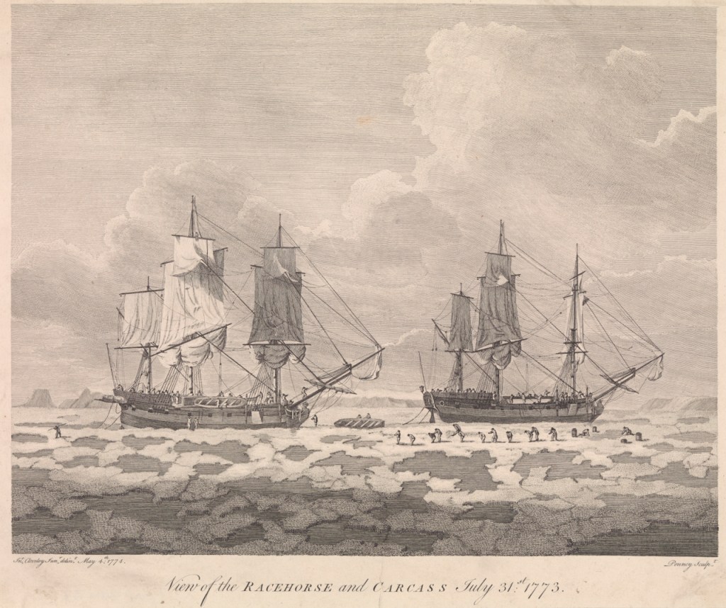
Racehorse leads Carcass towards the North Pole! The Exploration Vessels of the 1773 Phipps Arctic Expedition

On June 4th, 1773, HM Ships, Racehorse and Carcass set off from the Royal Navy’s Nore anchorage, in the Thames Estuary. While observers on nearby ships might have quipped about the unusual names of these vessels, what was most incredible was the mission the crews were being sent on: Commander Constantine John Phipps (the future Baron Mulgrave) was ordered to “proceed up to the North Pole, or as far towards it as possible…”1 In the words of crew member Olaudah Equiano, a self-emancipated former African slave: “I was roused by the sound of fame, to seek new adventures, and to find, towards the North Pole, what our Creator never intended we should, a passage to India.”2 The Phipps Expedition members would indeed have many Arctic adventures, and these were especially remarkable because – in spite of what sounds like an insane plan – the crews made it home!3

Racehorse leads Carcass through leads in the ice on 31 July 1773. This depiction faithfully records many of the unique details of the ships that are described in this post. Credit: Benjamin Thomas Pouncy (engraver); John Cleveley, the Younger (artist), Credit: National Maritime Museum, Greenwich, London. Caird Fund. PAF7943

This post will continue our series exploring the design and service of the Royal Navy’s polar-modified bomb vessels. For a description of their general design and an account of how they wound up serving as polar exploration ships, starting with HMS Furnace’s 1741 conversion, see our recent post. The Phipps Expedition is mostly mentioned today because of the presence onboard the junior ship, Carcass, of a young midshipman fated for great things: Horatio Nelson.4 This incredible Arctic journey has several interesting connections to the disastrous events of the 1845 Sir John Franklin Expedition.

Thirty years after the 1741-42 Christopher Middleton Northwest Passage Expedition reached the high latitudes of Hudson’s Bay, the next major Admiralty polar exploration mission, the 1773 Constantine Phipps Expedition, saw two ships depart England towards a radically different destination: The North Pole.5 The mission benefitted from the patronage of King George the Third and had the enthusiastic support of the Royal Society (RS). Royal Navy Commander and RS member Constantine John Phipps was appointed to lead the expedition from Racehorse, while Skeffington Lutwidge continued his earlier command of the junior ship, Carcass. RS Vice President Daines Barrington hoped the crews would discover an open polar sea to lead towards the “South Sea” (Pacific Ocean).6 The rationale for this mission tied in to eighteenth century speculation about easily-navigable shortcuts to the Orient over the Pole, or through Northwest or Northeast Passages.7 In his published journal -an important source for this blog- Phipps tapped into this wellspring of speculative geography and summarized more than two centuries of exploration history to the Arctic regions, and the “North Passage.”8

Admiralty officials had learned valuable lessons from previous discovery missions. The Earl of Sandwich, First Lord of the Admiralty, took a keen interest in the preparations. Peter Goodwin’s invaluable account of the Expedition includes a chapter of biographical information on the officers and crews.9 His research shows that the Phipps expedition personnel were a carefully selected group, led by exceptional officers, accompanied by civilians with wide-ranging scientific expertise. The “young gentlemen” – midshipmen on the journey – included Horatio Nelson and Philippe d’Auvergne. Nelson became the coxswain of one of Carcass’s boats, while d’Auvergne worked up a fine visual record of events of the expedition.10 The crews were of a higher professional standard than in 1741, when – in the midst of war – Middleton had had to resort to impressment to fill his manning requirements.11 One notable Able Seaman, whose skill led him to serve as one of the coxswains of the boats, was Nicholas Biddle. Biddle went on to become one of the early captains of the Continental (United States) Navy, serving with distinction. Like his fellow coxswain Nelson, he died at the height of a naval battle.12

The scientific establishment on the Expedition included the Ship’s Surgeon, Dr. Charles Irving. The ships were equipped with a desalination machine he had invented. Phipps, Irving and his assistant, Olaudah Equiano, worked diligently to ensure the machine produced a supply of potable water.13 . The board charged with questions of longitude selected Dr. Israel Lyons to proceed in Racehorse. Lyons excelled as both a mathematician and botanist.14 Phipps had also sought out the advice of naturalist Dr. Joseph Banks, who had furnished him with instructions about what types of natural specimens to collect.15

To mitigate the risk that the destruction of one ship would result in the loss of the entire expedition, two reinforced bomb vessels were prepared. The ships received significant modifications for northern service, in an incredibly short period of time in early 1773.16 The Admiralty’s original intention was to equip, crew, and provision the ships identically. Given that they did not share a common design origin, this appears to have left Carcass dangerously overloaded. In late May, Lutwidge was permitted to land six cannon and reduce his establishment of crew by ten members.17 Even so, the disparity between the hull types and rig meant that Racehorse lived up to her name, by surging far ahead of Carcass. The entries in Phipps’ journal and from other primary sources are remarkably similar to reports of Terror struggling to keep pace with Erebus on Sir James Clark Ross’s Antarctic Expedition of 1839-1843, and the reason is also similar: these ships did not have the same hull lines.18

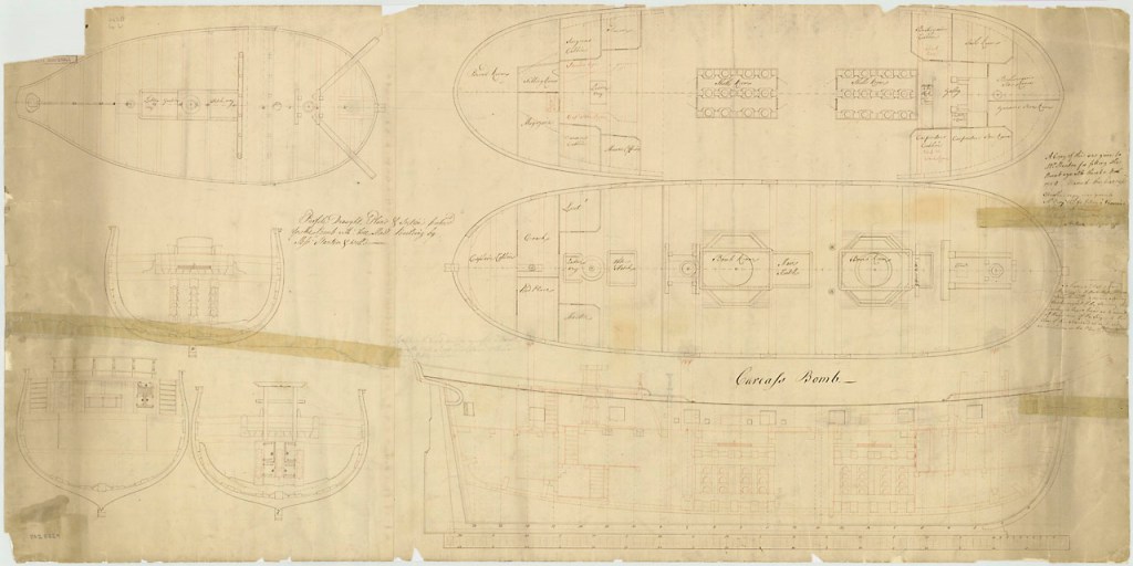
HMS Carcass, 1759. Showing the original design as a bomb vessel, deck arrangements over a simplified internal arrangement. This original plan shows the two heavy mortar beds and double-ended appearance of the rounded stem and stern areas. © Crown copyright. National Maritime Museum, Greenwich, London (ZAZ5629)

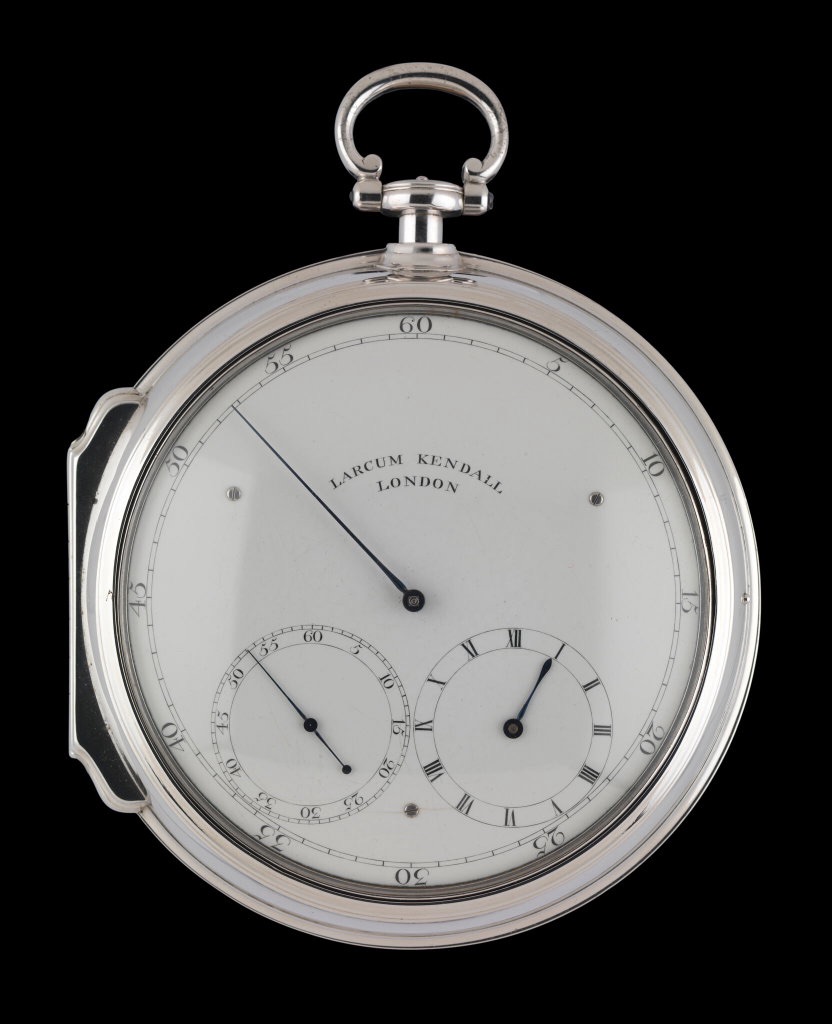
The expedition members were issued with proper cold weather gear (in contrast to the general sailing slops that had been allotted to Middleton’s personnel). Another first was the hiring on of a pair of Greenland pilots for each ship.19 These were experienced merchant ship’s masters, who had navigated “Greenlander” ships in northern waters.20 They would assist the officers and regular ships’ masters to help navigate local conditions in this unusual environment. Officers were equipped with a wide variety of updated navigational instruments and scientific devices. Like James Cook’s contemporary exploration of the Pacific, the ships carried updated timekeeping instruments, which employed John Harrison’s principles. These Larcum Kendall designs would allow for more accurate calculations of longitude than had previously been possible.

Larcum Kendall’s K2 marine timekeeping device. This was a simplified version of John Harrison’s design. This specific timepiece went with Phipps in Racehorse, then to the Pacific, and then with William Bligh in HMAV Bounty. It survived the famous events of the mutiny at Pitcairn Island, to ultimately be preserved at the National Maritime Museum. Credit: National Maritime Museum, Greenwich, London, Royal United Service Institution Collection (ZAA0078)

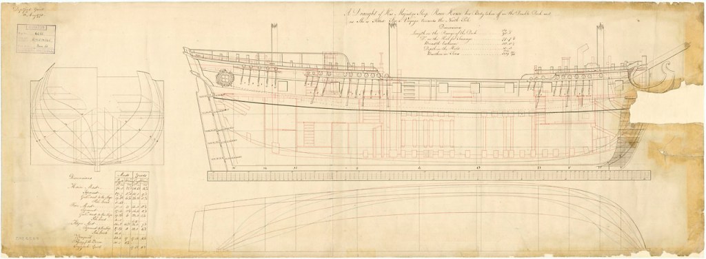
The Expedition vessels’ conversion for polar service have a basic similarity to the 1741 modification to HMS Furnace. The hulls were double-planked for strength. Vessels received capstans amidships, instead of the windlass in the bows.21 Smaller-sized vessels of the Royal Navy now were provided with (steering) wheels, unlike Furnace at the beginning of the 1741 journey. In contrast to later conversions, the gunports were not planked over. One important new modification was that the bows were reinforced internally with heavy buttressing timbers, to better withstand the force of collisions with ice or the strain of being beset in it. From surviving illustrations, the bow areas also appear to have received some external wooden sheathing, much like contemporary whaling ships. Both vessels received a varied complement of boats, intended to be able to accommodate the entire crew should their vessel be destroyed (we had mentioned the modification to the boats for over-ice hauling in a previous post). As events would show, this was a sensible precaution.

HMS Racehorse as converted for the 1773 Expedition, showing reinforced bows, and removal of forward mortar bed. © Crown copyright. National Maritime Museum, Greenwich, London (ZAZ6569)

The open waist area of the ships was not enclosed (merging the quarterdeck and foc’sl deck into one unified weather deck). The Admiralty had partially decked in this space on Furnace, on Middleton’s advice. They should have repeated this modification.22 A unified weather deck protects ships’ stores and important equipment, and also enhances crew comforts in Arctic conditions. This would have greatly improved conditions on the journey home, when both vessels almost foundered in a series of terrible gales. Close interpretation of surviving artistic depictions also suggest that the channels (where the masts’ shrouds attach to the hull) were not fortified or chocked (filled-in) as they had been in Furnace, leaving these projecting channels vulnerable to ice damage.23

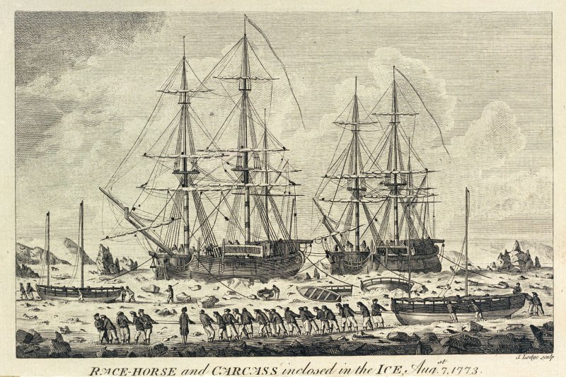
The northwards-bound vessels encountered ice starting on July 7th.24 The expedition charted the islands of the Svalbard Archipelago, and recorded various observations (astronomical, magnetic, depth sounding) as they went. No easy path towards – much less over – the Pole was discovered. The officers and scientists described what flora and fauna they encountered on the islands, and marine life they could dredge up from the depths. Phipps’ journal records the first scientifically-based descriptions of polar bears, which were shot and brought aboard for study. The expedition reached its highest northern latitude of 80°48′ on July 27th. The vessels and crew were severely tested in early August, when the ships could find no more open water leads to advance to the northwards, and were beset in thickening ice. This experience – while mercifully brief – was terrifying. It is one of the most relevant polar precedents for when Sir John Franklin’s crews of HMS Erebus and Terror had to abandon their iced-in vessels in late April, 1848.

Racehorse leads Carcass in pack ice. Boats have been swung out and fitted for hauling over ice, starting with the launches. Credit: Lodge, John (engraver), Public domain, National Maritime Museum, Greenwich London, Caird Fund. PAD5964 via Wikimedia Commons

On August 6th – with the ships trapped – Phipps took stock of his remaining provisions, and estimated that the health of the crews would decline rapidly if they were forced to overwinter out on the ice in this unprepared spot. The carpenters were instructed to modify the boats in order to have crew haul them across the ice in an effort to try to reach open water. They would then put to sea to locate Dutch whaling ships that were known to be anchored nearby at Smeerenburg, an abandoned settlement on Amsterdam Island. The next day, with the water shoaling, and the ice carrying the ships inexorably towards some rocks to the northwest, Phipps left Racehorse to lead a crew hauling the launch (the largest size of boat brought along) westwards over the ice. Crew also remained on the ships, which made slow progress westwards behind the boats. All parties remained in contact. As the crew hauled the boats along the broken, treacherous ice, favourable winds sprang up and the ships started to advance. Soon the exhausted crews returned onboard and the boats were swung back on deck. By the 10th the ships had driven through the remaining ice (with what sounds like some actual precedent-setting icebreaking), and were able to safely anchor at Smeerenburg (where there were indeed Dutch ships preparing to depart for the year). A mobile observatory was installed ashore. The officers described a nearby glacier, while Philippe D’Auvergne worked up another of his well-executed sketches of the scene.25 When the ships raised anchor, a few other attempts to make more northing came to nothing, as the season advanced and the ships came across a wall of ice. Phipps decided to turn for home on August 22nd.

In common with other polar expedition accounts, the voyage home was horrendous. By the second week of September, both crews were fighting for their lives in a series of terrible storms. The ships were both damaged in the gales that started the second week of September, and lost sight of each other. Each crew believed the other ship had likely foundered. The open waist area of the ships became a liability at this point.26 The vessels sighted each other again on the 25th of September off the coast of Suffolk.

In the years after Phipps and his crews returned, the Admiralty had to shelve further plans for Arctic discovery missions as it found itself embroiled in a series of wars that expanded to include the majority of the World’s oceans. It took until the final defeat of Emperor Napoleon Buonaparte, in 1815, for the polar exploration program to be revived (with Second Secretary of the Admiralty, John Barrow, taking a leading role). In contrast to the divisive legacy of the Middleton Expedition, Constantine Phipps’ Expedition was remembered in favourable terms. The modification of Racehorse and Carcass set many precedents for the next two bomb vessels to go north to the Arctic: Hecla and then Fury. Please consult the “Design Dossier” below for more technical information about Racehorse and Carcass.

Click for HM Ships Racehorse and Carcass Design Dossier and Endnotes

Christopher Middleton – the First Royal Navy Arctic Explorer – Crosses the Line in 1742

Traditionally, the Royal Navy’s program of Arctic exploration is represented as having commenced with the Constantine Phipps Expedition towards the North Pole in 1773.1 Phipps and his crews pushed north to above 80° latitude near Spitzbergen, before having to turn for home. Though the Phipps Expedition set many precedents for later polar exploration missions, it is Captain Christopher Middleton who deserves wider recognition for his trailblazing 1741-1742 Hudson’s Bay Expedition .2 This was the first Admiralty mission to search for a Northwest Passage.3 I will argue that Middleton also deserves credit for commanding the first Royal Navy expedition to explore an area north of the Arctic Circle.4 He had reached this far north in the first bomb vessel modified for northern exploration (which set the precedent for a century of discovery missions).5 During his time in Hudson’s Bay, he conducted a program of scientific research spanning several disciplines. After he arrived back in England, a dispute with Arthur Dobbs – his armchair-cartographer nemesis -marred his reputation and cast doubt upon his important discoveries.

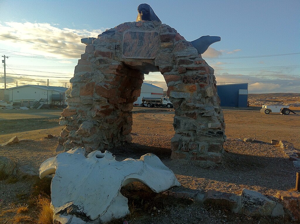
The Naujaat Arctic Circle Arch, a gateway to the Canadian Arctic. Credit: Wes Gill from Winnipeg, Canada, CC BY-SA 2.0 https://creativecommons.org/licenses/by-sa/2.0, via Wikimedia Commons

Early on the morning of August 7th, 1742, Captain Christopher Middleton nervously paced the quarterdeck of His Majesty’s Ship Furnace.6 He and his crew believed they were on the threshold of a historic discovery: A northwest passage towards the “South Sea” (the Pacific Ocean). These explorers had diligently clawed their way up Roes Welcome Sound, between the northwestern shores of Hudson’s Bay and Southampton Island. Standing into danger, they had picked their way around “islands of ice” (icebergs) and “ledges” (land floes). When they could find no favourable winds, they had even used cables anchored to the ice to haul the ships north from berg to berg.7

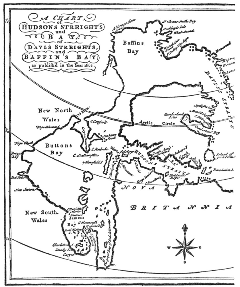
A Chart of Hudson’s Straits and Bay, of Davis Straits, and Baffin’s Bay; as published in the Year 1668. This shows the extent of knowledge about the Bay after the Henry Hudson, Thomas Button, Luke Foxe, and Thomas James expeditions of the first half of the seventeenth century. “Buttons Bay” and much of the NW and SW coasts of the Bay was conjectural.8

In the hazy morning twilight of those extended northern days, Furnace had been working around a promontory which Middleton had just named “Cape Hope.” He believed this could represent the “extreme part of America,” (or the northern most point of the North American continental landmass) a major milestone along the way of achieving his Admiralty mission to discover the fabled maritime route westwards.9

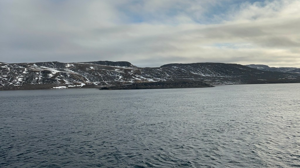
Zenith Point, Murchison Promontory, on the southern shores of the Bellot Strait, is the highest point of land of continental North America, or what Middleton would have called the “extreme part of America.” It was discovered in 1852 by William Kennedy and Joseph-René Bellot. It is an important waypoint on one of the main routes of the actual Northwest Passage through the Arctic Archipelago, and is located at 72’00’06” latitude north, 740 km NNW of Middleton’s Cape Hope. Photo by author, 5 Sep. 2025.

Middleton was a skilled navigator, who had outfitted his ships with the latest navigational devices. He employed these to survey under exceptionally challenging circumstances.10 His career had prepared him for the rigors of commanding a discovery mission in the Bay.11 After early service aboard a privateer in North American waters (during Queen Anne’s War, 1702-1713), he had worked for many seasons as a merchant captain with the Hudson’s Bay Company (HBC), sailing between England and the HBC factories of the Bay on yearly supply missions.12 His experiences commanding HBC sloops had led him to enthusiastically support a popular European belief that the undiscovered shores of the Bay concealed the beginnings of the Northwest Passage.13 In early 1741, with the support of an influential ally and confidant, Arthur Dobbs, he had left HBC service to secure the command of an official Royal Navy exploration mission.14 The crews of his two ships – Furnace and the small tender Discovery – were the first Europeans to navigate these waters (whose adjoining lands were the ancestral territory of the Aivilingmiut Inuit).15 They had endured many hardships since departing England on 8 June, 1741. A dozen of their mates had already perished.16 The dedicated assistance of both the HBC staff and local indigenous communities at and around the post at Churchill, over the winter of 1741-42, had prevented a much greater loss of life.17

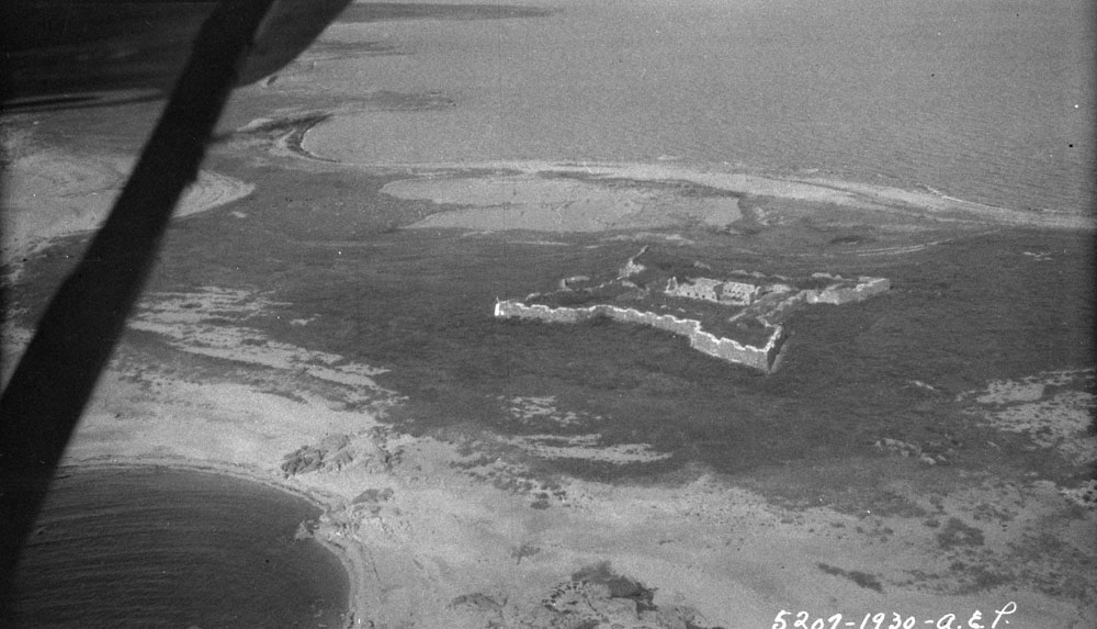
Prince of Wales Fort, aerial view from 1930. The fort sheltered the Middleton Expedition’s senior staff at Churchill, while the crew were lodged in the old, disused post upriver. Middleton, during his HBC career, had been involved in this massive fortification’s original design.18 Credit: Alf Erling Porsild / Department of Indian Affairs and Northern Development fonds / Library and Archives Canada / a101002-v8

As the sun burned off the haze, the watch on deck sighted high land continuing westwards from under the cape – So far, so good. But then a low shoreline materialized across Furnace’s stout bows. The land stretched around to the starboard beam. This day would bring no happy run far to the west – Christopher Middleton had discovered another bay.19 Disappointed at being “embayed” and turned away from his main objective, he named these waters “the Bay of Repulse” (the Inuktitut name for these enclosed waters is Aiviliup Tariunga). The next few days would see the expedition halted from further progress north by an impassable barrier of ice at the top of Southampton Island. The captain went ashore with two healthy crew members and an indigenous guide, climbed to the highest point he could find, and surveyed the distant shores. From this vantage he saw an iced-over passage extending towards the east, and named this the “Frozen Strait.”20 Given what would befall him upon his return home, Middleton may well have lived to regret ever having been up here in 1742. Today we can acknowledge that he started something in this northwest corner of Hudson’s Bay: An organized program of northern discovery that would eventually see the mapping of vast extents of what would become the Canadian Arctic.

The entry from Furnace’s ship’s log for 6 August 1742, illustrating the hopes and then disappointment of the crew. A selection of the log is reproduced in his Vindication. (Cited below) Middleton’s observed position for this day was 66°44’ north. 21
Click Here to Continue exploring Northwards

Where we poor sailors do sometimes dwell – The Middleton Northwest Passage Expedition Roll of Honour

This post commemorates the sailors who perished during Christopher Middleton’s Royal Navy exploration mission to Hudson’s Bay (1741-42).1 It can serve as a Roll of Honour for these early explorers. For the context to this effort to locate the fabled passage to the Pacific in the waters of Hudson’s Bay, please see our post on HMS Furnace‘s unique exploration design. Our next post will argue that Middleton’s ship crews should be considered the first Royal Navy polar explorers.

Throughout the many wars and infrequent peace of the eighteenth century, the Royal Navy expanded into a massive fleet sailing from establishments strategically located along the seaborne trade routes. This growth came at a tragic cost: the human toll of crewing this British “wooden world” was staggering.2 Amidst all this death, it may seem odd to commemorate a dozen seafaring explorers who died in an incredibly remote outpost of British Empire. These were some of the very first deaths in a program of British naval exploration of what is now Canada.3 They would not be the last.

Christopher Middleton’s Northwest Passage Expedition departed the Nore, 8 June 1741. He had experienced significant problems filling out the complements of both his small ships, at their anchorage of Gallions Reach, near Woolwich.4 The seamen who wound up crossing the Atlantic to go looking for a northwest passage in Hudson’s Bay included conscripted men.5 According to their commanding officer, these ninety men were a “crew of rogues.”6 After transiting the Hudson’s Straits into the Bay, a council of officers decided to head for the Churchill River (present-day Manitoba), to overwinter. They would commence their search mission early the next navigation season. At their arrival near the Hudson’s Bay Company (HBC) establishment, Fort Prince of Wales, crews laboriously cut both ships into secure docks to overwinter in Sloop Cove.

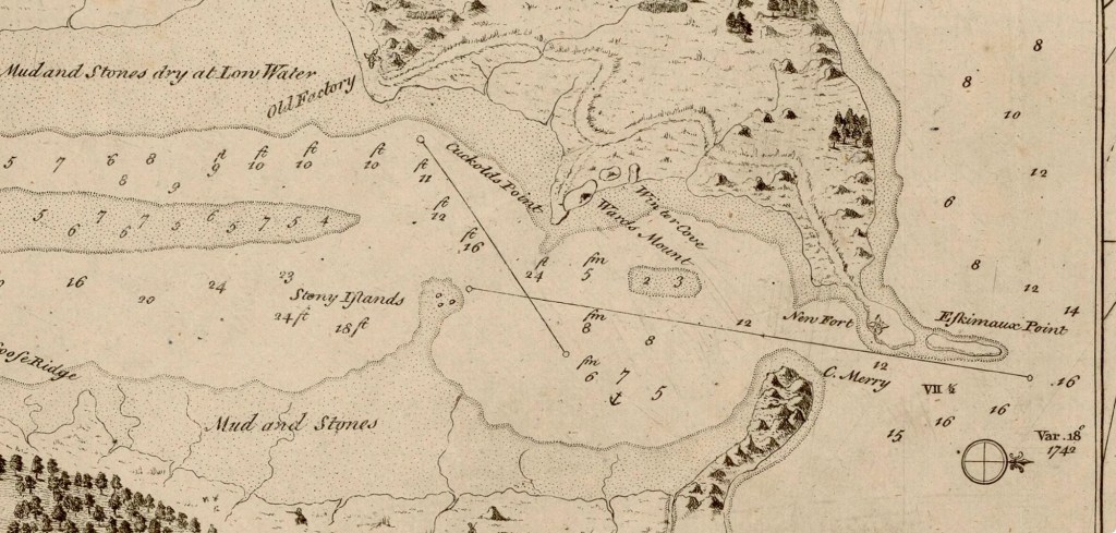
John Wigate’s map, “Chart of the seas thro which H. M. S. Furnace passed for discovering a passage from Hudson’s Bay to the South Sea.” Despite falsified sections of the NW coast of Hudson’s Bay (to support Arthur Dobbs’ spurious claims), this 1746 map includes this remarkably accurate inset plan of the mouth of Churchill River. On the northern shore, the “Old Factory,” Sloop Cove (“Winter Cove”), and the impressive Vauban-style “New Fort” are clearly indicated. If any of the crew were buried ashore, they should be located closer to the old factory. Credit:
Bibliothèque nationale de France, département Cartes et plans, GE SH 18 PF 123 DIV 3 P 6 via Wikimedia commons.

These northern explorers weren’t equipped with the types of cold weather gear that later expeditions would benefit from. While the officers were lodged at the new fort, crew spent a difficult winter billeted in the “Old Factory,” the former HBC trading post. Several members suffered from frost bite, and the naval surgeons were routinely called over to the old HBC factory to amputate damaged toes before gangrene spread. Worse still, scurvy made an early appearance in the Fall. This dreaded mariner’s disease continued to be a feature of the Expedition all the way back to the Thames, and would eventually claim ten lives. But for Middleton’s desperate attempts to secure fresh meat and vegetables, and the intervention of local indigenous hunters (from the Dene and Cree communities who traded near the HBC Fort and who supplied the expedition with huge quantities of foul), there would have been many more deaths.

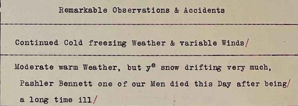
The transcribed page of the journal for 29 December 1741, recording P. Bennett’s death – the first Middleton Expedition death at Churchill. Credit: Library and Archives Canada, Arthur Dobbs fonds, LAC MG18-D-4 volume 4.

I feel it important to compile the names of these early explorers, their dates of death, and the causes, based on the original expedition journal entries and associated contextual documents found in William Barr and Glyndwr Williams’ edited Hakluyt Society publication:


William Clark, sailmaker Furnace 28 July 1741 drowned after a fall from fore shrouds in Hudson’s Straits7;

Pashler Bennett (or possibly “Paskler Bennet” 29 Dec. 1741 (scurvy at Churchill)8;

Christopher Row 13 February 1742 (scurvy at Churchill);

Edward Matthews 21 February 1742 (scurvy at Churchill);

Abraham Page 13 March 1742 (scurvy at Churchill);

John Blair 21 March 1742 (scurvy at Churchill);

Henry Spencer 26 March 1742 (scurvy at Churchill);

James Thrumshaw 28 March 1742 (scurvy at Churchill);

Ralph Pearce Carpenter’s Mate Discovery 9 April 1742 (scurvy at Churchill);

John Furnix 24 May 1742 (scurvy at Churchill)9;

Robert Rattery 31 May 1742 (scurvy at Churchill);

John Matthews Master’s Servant Furnace 20 June 1742 (drowned at Sloop Cove near Churchill)

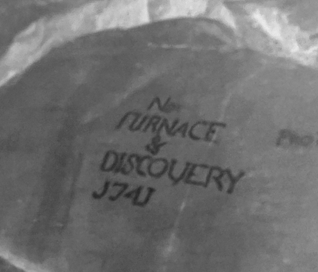
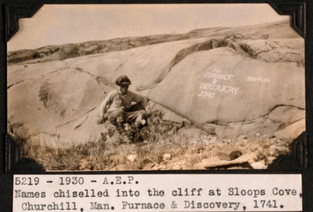
Sloop Cove rock inscriptions from 1741 overwintering of HMS Furnace and Discovery, as photographed in 1930. A series of inscriptions, including one by explorer Samuel Hearne, are preserved at the Sloop Cove National Historic Site. This may be the closest thing to a memorial the lost crew of the Middleton Expedition have. Credit: Northwest Territories (Album 31). Credit: A.E. Porild, Canada. Dept. Indian and Northern Affairs / Library and Archives Canada / e010983471

In some sources Middleton referred to two or three additional deaths. If anyone locates a reference to these other fatalities, or has any information about any known shore burials of the men who died near Churchill, please leave us a comment below.

Click for endnotes: