Launching a Sad Little Boat Model

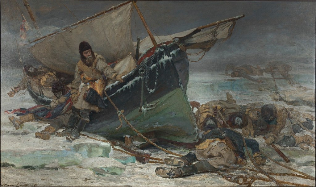
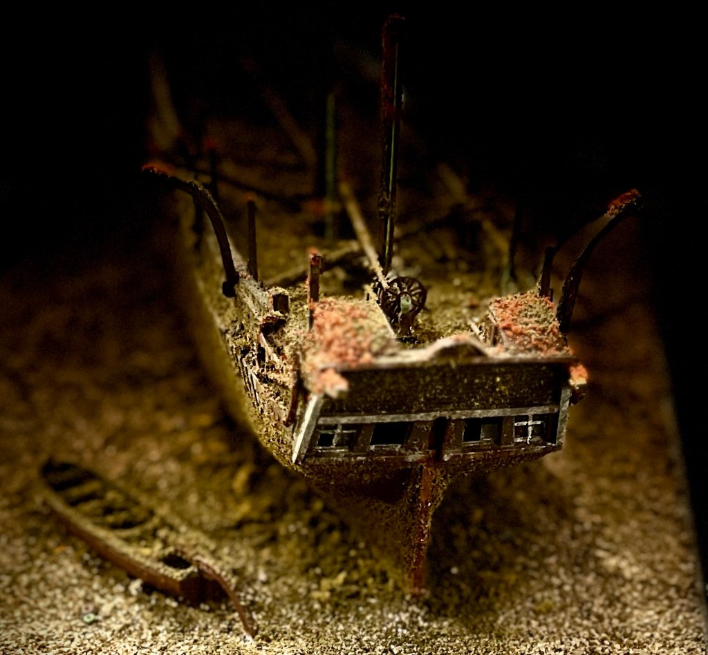
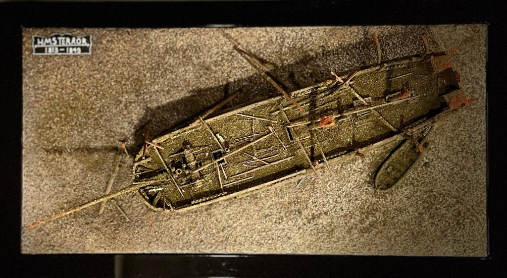
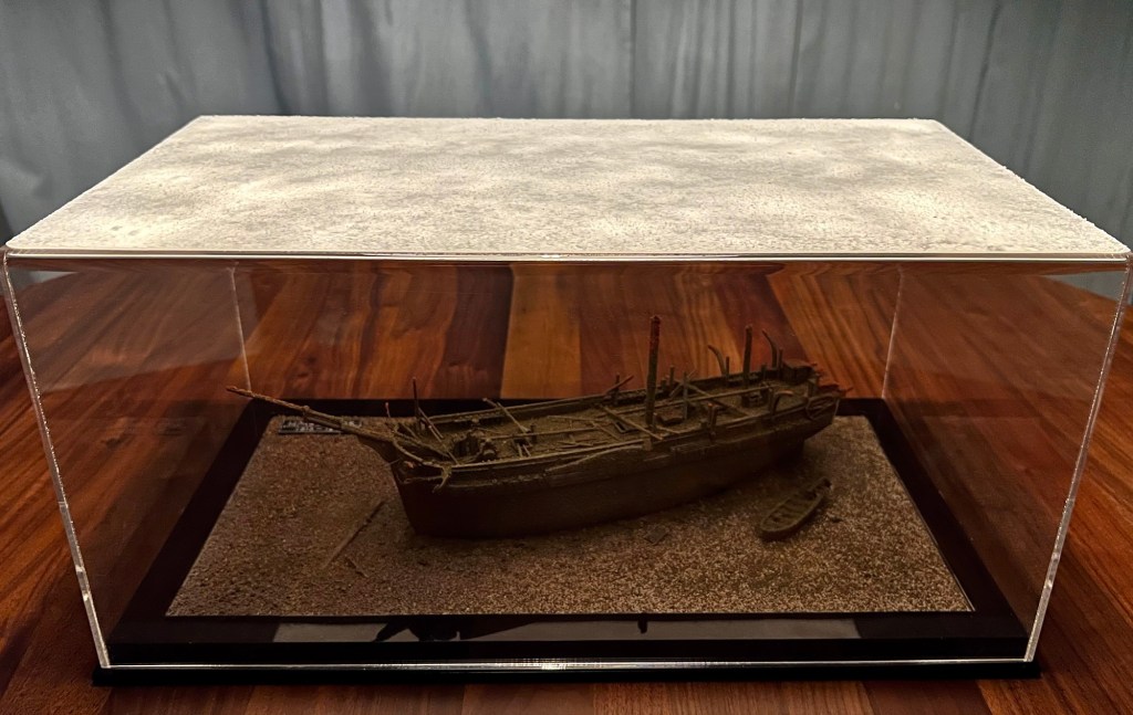
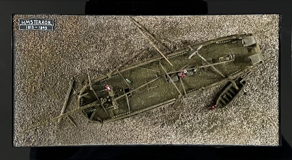
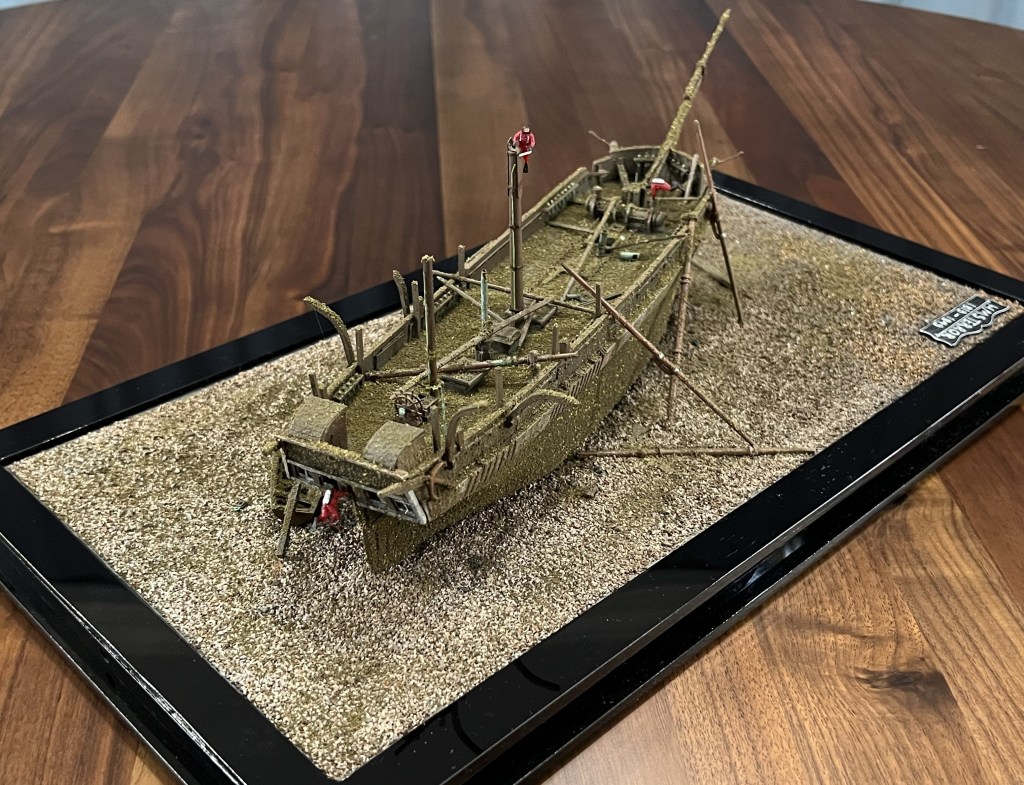
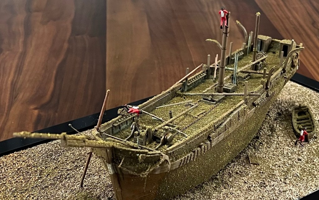
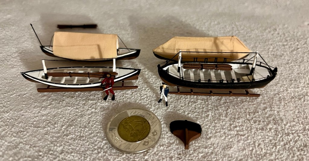
What if we could rebuild the “Boat Place” Franklin Expedition boat from its wrecked and scattered remains? In this post I will show my efforts to reconstruct the important boat I explored last week, at the same small scale as the HMS Terror wreck diorama.

The 2.4″/6cm long model on its sledge. Credit: http://www.warsearcher.com

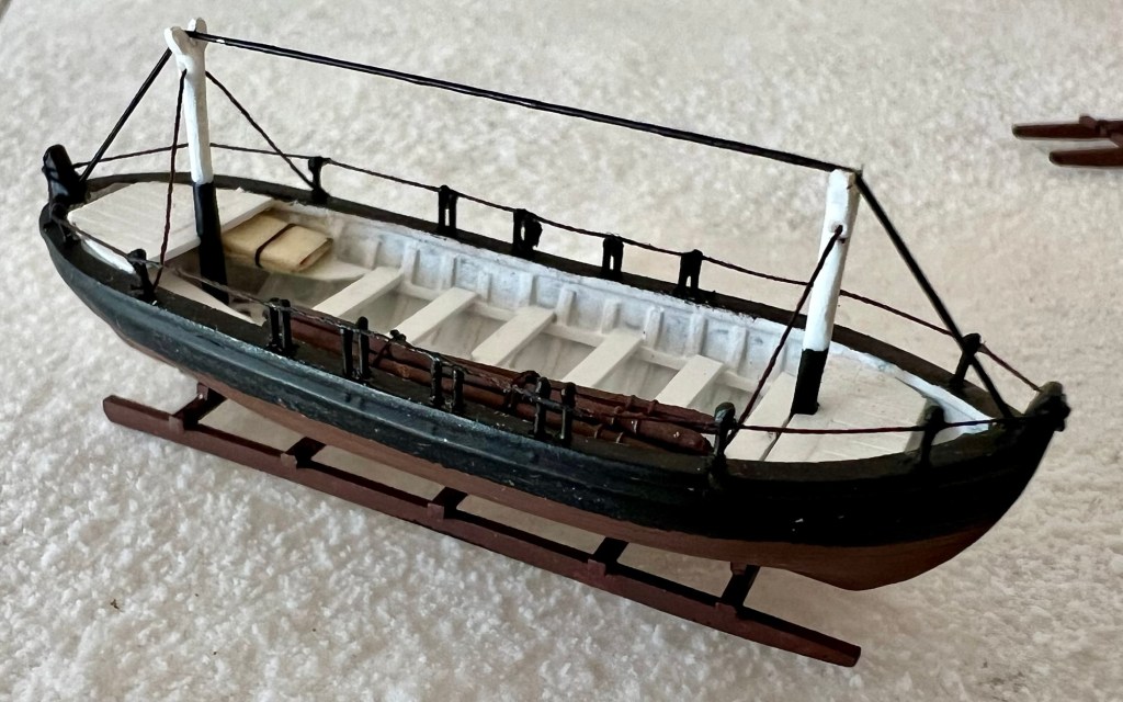
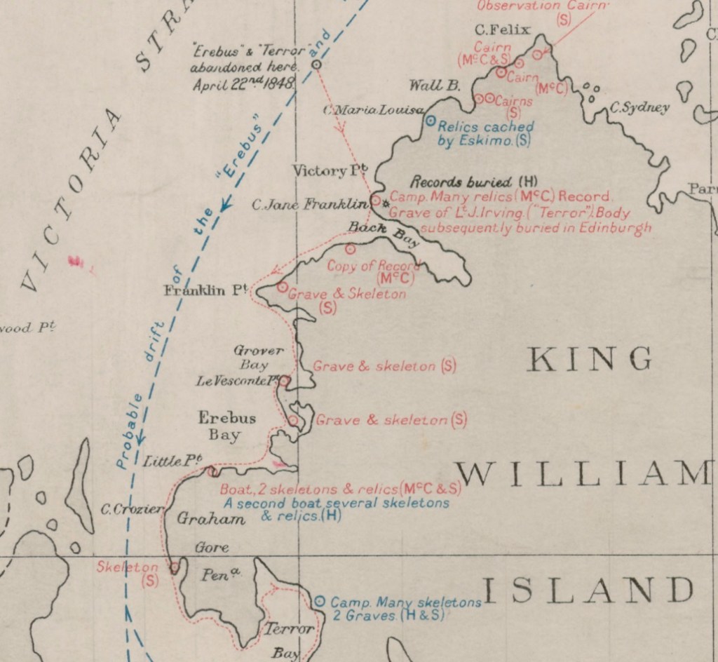
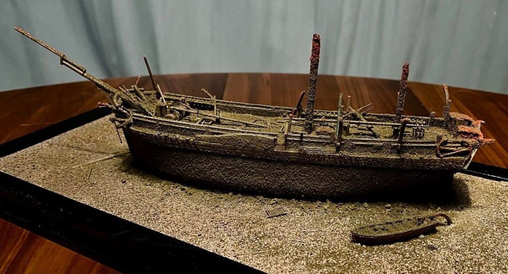
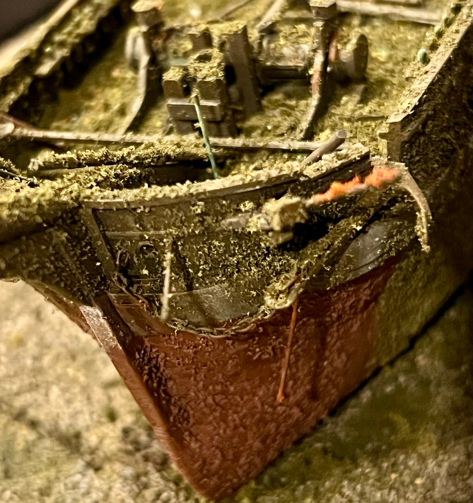
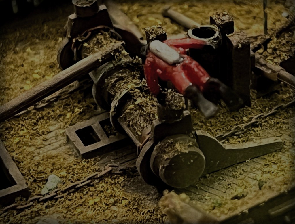
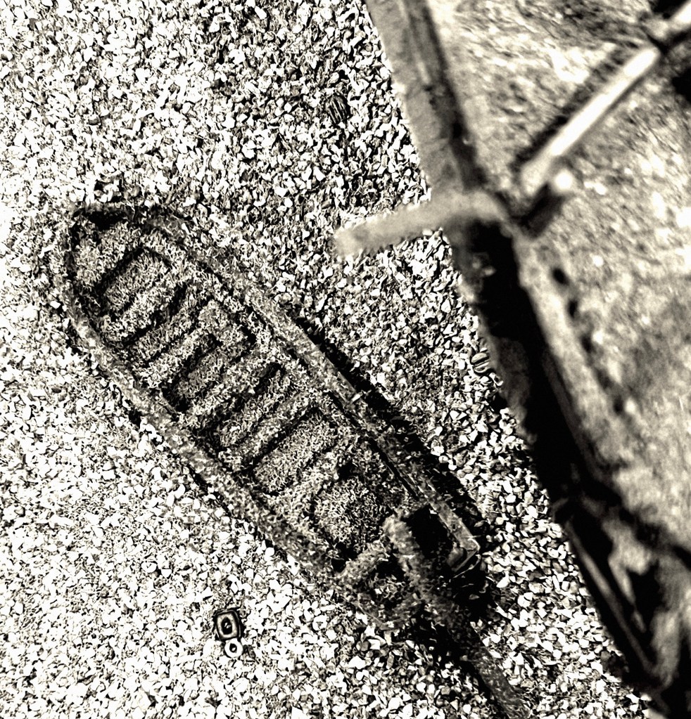
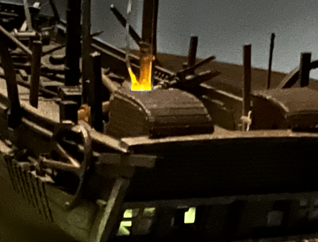
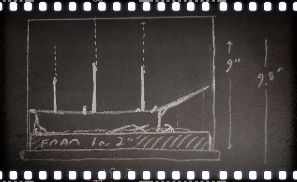
In early 2025 I set about transforming a tiny plastic model to represent the boat and sledge that searchers looking for the lost Sir John Franklin 1845 Expedition came across in 1859 on the western coast of King William Island.1 My research is summarized in the “design dossier” section of my recent post on this discovery. Stages of my build resembled some of the real modifications ship carpenters would have worked at early in 1848, as they prepared to desert HM Ships Erebus and Terror – I sawed off the old square transom (visible in the below photo) and reshaped a sharp or rounded stern using Milliput putty around a balsa wood carved-out form (later removed), and built a new curved sternpost. I added two gudgeons, on the chance that the boat could have been fitted with a rudder. As of this writing, I believe the converted boat was based on the hull of the lighter 25’ Cutter instead of the Pinnace (see below boat dimensions section for detailed information).

The model boats. The sharper and narrower whale boats are 30 scale feet long. The original square transom of the model appears beside the two-dollar Canadian coin. Credit: http://www.warsearcher.com

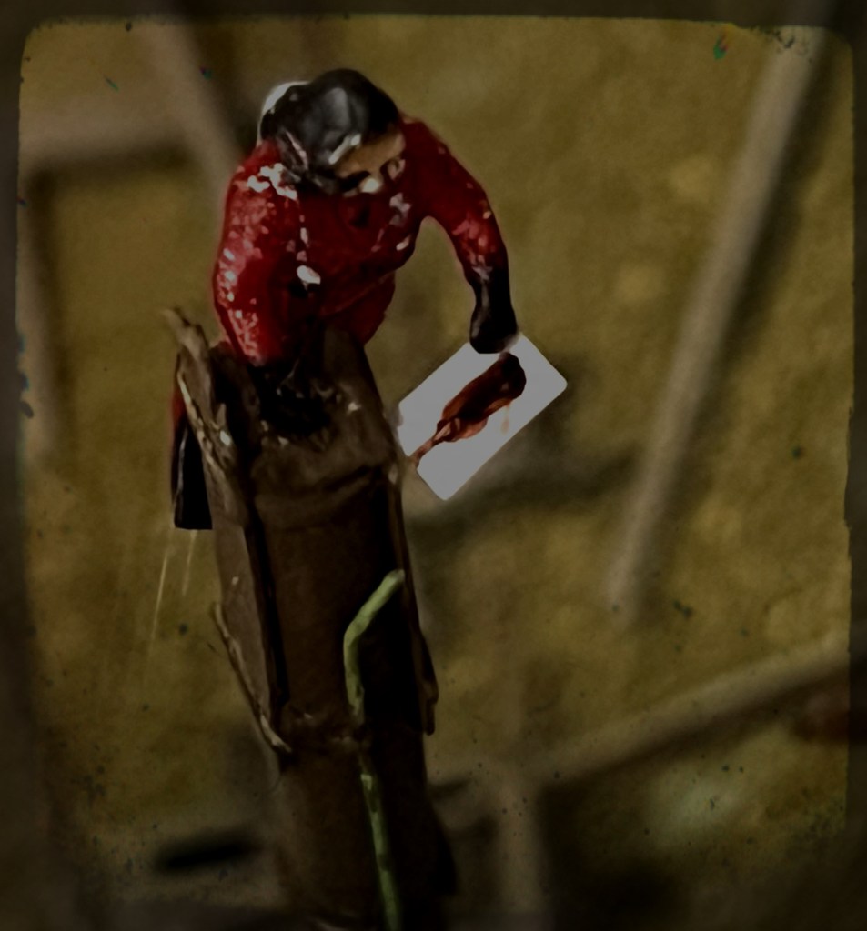
I modelled the stanchions (the two posts rising out of the hull painted two-tone black and white) to be high, with gaff jaws at their tops (as described by Lt. Hobson). Some practical tests with the model revealed that the pronounced list observed in 1859 meant that, in order for Hobson’s team to have spotted anything emerging from the high drifts of snow, that stanchion would have to be significantly taller than represented in most reconstructions. With its gaping jaws open to the sky, it must have appeared a grim marker, indeed!

The model and sledge with a list down to starboard, buried in a drift of snow in my backyard. Credit: http://www.warsearcher.com

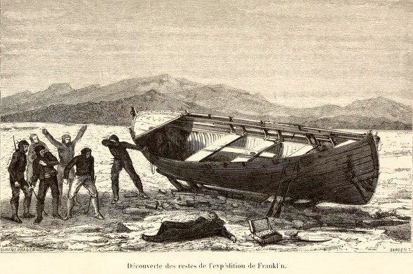
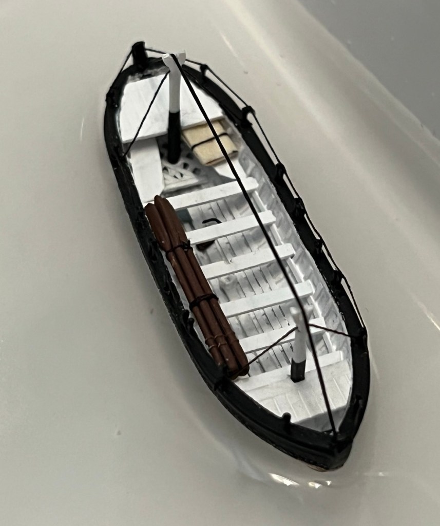
I decked over the bow and stern areas based on the Durand-Brager illustration (seen in the last post). The internal layout is similar to the whale boats that the ships carried. I like to think that the crews had a space in each boat to shelter an exhausted or ill member. A foredeck and covered stern sheets may also help explain the decade-long survival in decent condition of some of the artifacts that Hobson and McClintock discovered in the boat.

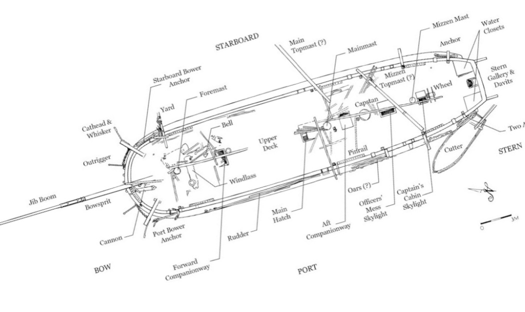
The gunwales were drilled for the thowells – tiny metal rods. I believe there was no washstrake boards, so I spaced the twenty-four thowells to support a washcloth that wrapped around the hull between the posts. Hobson noted these thowells (National Maritime Museum artifact AAA2143) were doubled up to assist the paddling. I paired them to create four rowing positions a side, and ran a rope along the top of the thowells, which the washcloth would have been rove into along its top edge.

The awning, and “cutaway” view. It is also possible that the awning connected directly to the gunwales, and not to the tops of the stanchions, which may not have been fitted while sledging on land. Credit: http://www.warsearcher.com

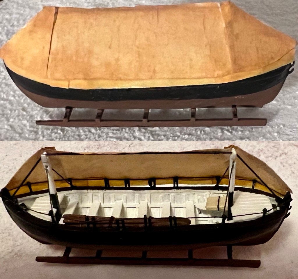
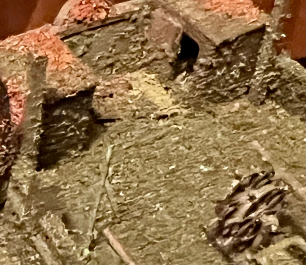
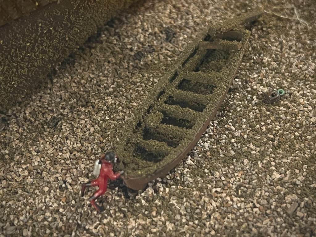
Artifacts currently placed in the model hull include six modified oars (cut down with add-on blade extensions), the sheet block (AAA2198), the folded-up lead sheets (AAA2280), and some sailcloth that could be the awning or the washcloths (AAA2144). Basic pieces of boat equipment, such as two masts, and a rudder, have never been found. I have added a mast step amidships, in case information or evidence of these details turn up. When under sail, the boat would likely have carried lugsails on its two masts.2 I hope someday to model the ice grapple/anchor encountered by the searchers. The bewildering assortment of personal items, cutlery, packets of chocolate, and human remains have not been represented.

The model takes to the water. Credit:www.warsearcher.com

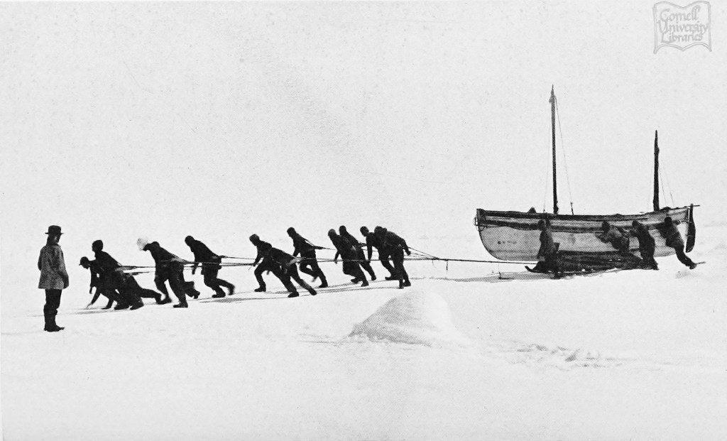
This boat and sledge combination may look unwieldy, especially when compared to the supremely well-adapted Inuit equivalents: animal hide boats (Umiaks) on sledges built of lightweight organic materials. But in 1859, Francis Leopold McClintock – a masterful long-distance sledge traveler – seems to have been impressed by the lost crews’ efforts at lightening it.

As with so many of the specifics about the 1845 Franklin Expedition, we continue along our own voyages of discovery. This is not the first interpretation of the Erebus Bay boat, nor will it be the last. I have created a sad miniature of that “melancholy relic.” [Read more in the Appendix below for technical info about the boats and sources]

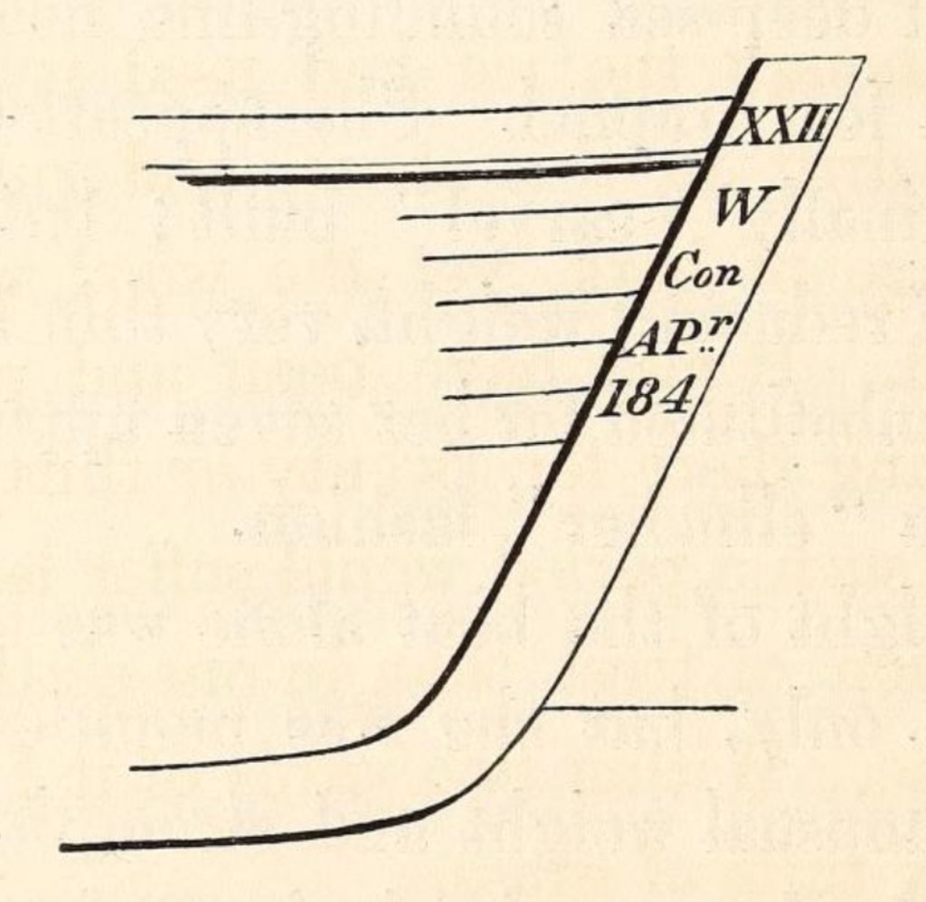
Appendix-JC Ross (1839) and Franklin (1845) Expedition boat types and sizes and notes:

Interpreting that “Melancholy Relic” – the Erebus Bay Boatwreck

In this post I will describe the “boat place” boat at Erebus Bay that searchers looking for the lost Sir John Franklin 1845 Expedition came across in 1859. A later post will show my effort to construct a small model of this unique and sadly-fated boat, and propose some likely dimensions of the full complement of Franklin boats.

William Thomas Smith’s powerful 1895 work “They forged the last link with their lives: HMS Erebus and Terror, 1849-50.” The boat has several well-researched components, such as the washcloth around the gunwale and the ice grapnel. It also appears rigged for sailing with full masts stepped. (CC-BY-NC-ND) copyright: National Maritime Museum, Greenwich London

On May 23rd, 1859, at a wide bay on the frozen western shores of King William Island, a group looking for the lost Franklin Expedition found something incredible: A large boat on a sledge. Fourteen years after Franklin’s two ships had left Greenhithe, England, searchers had finally arrived at “ground zero” of the Franklin Expedition escape saga. They were a decade too late. Quartermaster Henry Toms and Carpenter’s Mate George Edwards – both members of Lt. William Hobson’s detached sledge party searching the coast as part of Francis Leopold McClintock’s Franklin search expedition – first spotted something odd projecting out of the snow as they scouted ahead of their mates.1 Closer examination revealed it to be a wooden stanchion, hanging like a beacon over the curved outlines of a gunwale in the high drifts of snow – beneath their feet was the ghostly outline of a large boat.

Chart showing the vicinity of King William Island with the various positions in which relics of the Arctic expedition under Sir John Franklin have been found / compiled by Lieut.-Cmdr. R.T. Gould, R.N [detail of]. “Boat Place” is indicated in red text at the base of Erebus Bay. Credit: Library and Archives Canada 3674742

The next morning Hobson’s group began in earnest a two-day process of clearing out the site and inventorying an unusual assortment of artifacts. That stanchion also marked a gravesite – the resting place of at least two unidentified Royal Navy crewmembers who were entombed within the hull. McClintock’s sledge team arrived a few days after Hobson had departed. His published description of what he called this “melancholy relic” is the standard account of the site.2 But Hobson had also drafted a report on his sledge team’s discoveries, which included a detailed description of the boat. We are indebted to archaeologist Dr. Douglas Stenton’s work resuscitating Hobson’s report about his journey from obscurity. Stenton’s publication of the report provides important additional details to help explore the boat place.3 Since Hobson’s team had excavated the snow from the boat and examined the objects found therein, the site had already been altered before McClintock’s party reached it. For a detailed list of the interesting and unusual contents of the boat, please see Russell Potter’s Visions of the North blog “The Boat” on the topic. My interest here remains focused on the boat itself.

This early 1860s illustration represents some of the major relics accurately, and shows the double-ended appearance and large proportions of the vessel. Credit: Durand-Brager, from Arthur Mangin, Voyages et Découvertes outre-mer au XIXe siècle, illustrations par Durand-Brager, 1863 ː Découverte des restes de l’expédition Franklin. Public domain, via Wikimedia Commons

The Erebus Bay find remains the only Franklin Expedition boat and sledge, originally encountered reasonably intact, whose appearance and contents were described in detail. Its importance is tied to the slightly earlier discovery by Hobson’s party of the Victory Point record, in a sealed cylinder in a cairn about 60 km northeast. An update to a routine Admiralty form mentioned the abandonment of the long-beset ships, and recorded captains Crozier and Fitzjames’s intention to mount a desperate trek with their ailing crews towards Back’s Great Fish River. The note had no specific information about how they planned to cross the vast distances involved. The Boat Place discovery seemed to illustrate the mechanism of the evacuation plan: Crew members would use drag ropes to man-haul boat/sledge combinations down and around the coastline of King William Island. They would then unship the sledges and navigate the boats to the mainland and down a treacherous river towards a still-distant fur trading post. We don’t know how this plan changed as they struggled along, losing more men, and abandoning more boats. Some of the last of a group of weary men laid down to die, under another boat, on the mainland at Starvation Cove.

Back at Erebus Bay, the 28’/8.5 m boat was found just above the frozen shoreline. It listed dramatically down to starboard. A hole may have allowed wildlife – bears or scavenging foxes – access on the low side. Both boat and heavy sledge were oriented back towards the northeast, though if that was by intent (to return towards the ships), or by happenstance, no one can say. McClintock commented on both the boat’s lightness, and the sledge’s weight. He estimated the weight of the boat to be about 700-800 lbs while the sledge could have been as much as 650 lbs (the average weight of a 28-foot whaling boat, by contrast, was about 1,000 lbs).4 His observations were informed by his great expertise in sledging, acquired during his participation on this and earlier expeditions.

A remarkable 3D interpretation of “Boat Place.” This well-researched depiction of the boat and sledge is a recent and valuable addition to the artistic reconstructions of Erebus Bay. It was inspired by Matthew Betts’ reconstruction (see notes). The outlines of one of the ships in the distance heightens the pathos of this bleak scene. Certainly, the ships did transit by the Bay at some point after April 1848. Used with written permission of Case Western, who maintains a site with 3D printing models.

The boat had been modified by the ships’ carpenters – the square transom at the stern had been removed and the boat was now pointed or “sharp” at both ends, with a curving stem and sternpost, like a broader, deeper version of the two ships’ whale boats. The “carvel” planking (flush-edge-to-edge) of the top strakes of the hull had been replaced and lighter fir “clinker” planks (overlapping) re-laid in their place. An ingenious washcloth design of canvas was fitted in the place of the heavier washstrake boards. The set of six paddles – cut-down oars converted with larger “add-on” blades – indicate that the boat had been converted for inland/river navigation.

The stem, as drawn by McClintock in his 1859 edition of The voyage of the ‘Fox’ in the Arctic seas: A narrative of the discovery of the fate of Sir John Franklin and his companions (P 292) see notes section for link.

The distinctive stem of the boat was sketched by McClintock. This was recovered two decades later by American Franklin searcher Frederick Schwatka, who, while looking for records, was leading the first expedition on King William Island that encountered the sites in the summer, not under cover of snow and ice.

According to Inuit oral testimony, there was at least one other abandoned boat with many more skeletal remains that was located nearby.5 Both boats were dismantled in the early 1860s for their useful materials and fittings. Following the initial recovery of some artifacts, the dismantling, and Schwatka’s later removals, only archaeological traces and a memorial with bone fragments remain at the site – the last vestiges of a melancholy relic.

Another famous boat/sledge with a less tragic outcome, the James Caird, originally one of Sir Ernest Shackleton’s 22.5’/6.9m boats from his exploration ship Endurance, being dragged across the sea ice in Antarctica, Dec. 1915. Credit: Frank Hurley : via wikimedia commons.
The Design Dossier and References (click here):

The Great Terror Wreck Repair[2025]

A basic principle of model shipwreck archaeology is that – in contrast to their full-size brethren – model shipwrecks do not necessarily deteriorate. In this post we explore updates to our miniature interpretation of HMS Terror’s wreck. The Terror mini-site has witnessed substantial improvement since 2022!

Terror’s rebuilt stern, with new rudderpost, gudgeons to hang the absent rudder, a broader stern tuck up to the sternlights (windows) and lower water-closet deckhouses aft of the double wheel.

An earlier post “Wrecking the Terror: Recreating an Epic Tale of Old Loss and New Discovery” summarized what we know about the actual wreck of HMS Terror located in Terror Bay, Nunavut, and my 2022 project to build a small diorama of the wreck site. Terror, an astonishingly well-preserved time capsule of the last Franklin Expedition, continues to captivate Franklin scholars and enthusiasts, archaeologists, naval historians, ship lovers, and the expanding fandom community who continue to enjoy the fictionalized drama of AMC’s “The Terror”(season 1).

HMS Terror site sketch, 2017 copyright Parks Canada 2021 [modified by rotating]. Source.

Turning now to the reduced-scale World, Terror was my first wreck diorama, and was followed by Breadalbane High Arctic shipwreck and HMS Ontario.

A “glass-bottomed boat” view of the updated wreck site, 80 scale feet under the acrylic case top. The shadow of the bowsprit points due north.

Two years after I thought the diorama was complete, I decided it was time to open the case up and revise some features. A sketch I had worked up independent of this project also helped motivate me to rebuild the Terror.

So what changes has the miniature site undergone? The entire lower hull was reshaped to better highlight the turn of Terror’s bilge, the overall body lines, and the broader aft quarters. The wreck was also placed at a more pronounced list to starboard. I added more detail to the debris of fallen masts and yards now located on the upper deck, which better interprets the complexity of the three-masted barque-rig and the chaotic event of the sinking. This “top-hamper” – and what appears to be the ridge poles of winter awnings – would have showered the deck and areas immediately adjacent to the hull with the types of debris we see in the site plan released by Parks Canada, and imagery released by their Underwater Archaeology Team.

The weather deck looking forwards from the taffrail.

Under all the accumulated silt and growth, there is likely to be a bewildering variety of artifacts, which my interpretation can only begin to hint at. The ship’s boat off the port quarter of the wreck was given a modest update: A more accurate fallen davit resting across the stern.

The bows including the port bower anchor, the hawse holes, the catshead with whisker boom, and other oddities of the polar-modified bomb vessels. under the reinforced channels, the massive ice shield of iron plates shows corrosion and marine life.

The water-closet structures at the stern were completely rebuilt with lower roofs and sliding doors opening to the sides. They still have detailed “privy” interiors. A small cavity at the aft end of the starboard closet shows where the flag locker was located.

The new stern water closets, the double wheel and the captain’s skylight just forward of that. In the foreground, a pipe leads down to the captain’s small stove.

The interior of the wreck diorama remains practically inaccessible, and no substantial work was done belowdecks during our “great repair.” I do hope that, in a future season of modelling work, a more fulsome recording of the detailed interior spaces of the model could be attempted. For now, we had a quick examination of Capt. Crozier’s miniature great cabin through the stern windows; his captain’s desk remains in place, but the drawers are still modelled tightly shut. No miniature records have yet been recovered.

Light shines down through the captain’s skylight onto the surface of Crozier’s desk.

Those with keen eyes will note that the team of scuba-diving archaeologists have not been reinstalled in their customary positions. The site is currently under ice and snow, and they will not return to their program of scale archaeology until the next dive season commences in August, 2025. Could I contemplate a scenario where new information would compel me to get back to work revising the Terror diorama? You bet your sextant I could!

The diorama with its winter cover of ice and snow.

Wrecking the Terror: Recreating an Epic Tale of Old Loss and New Discovery

With a shipwreck…you are dealing with a single instant in which everything was pitched onto the seabed; and, because water can be a wonderful preservative, in the right circumstances, the wreck and almost everything within will still be there. A wreck can be a perfect time capsule.” (Mensun Bound The Ship Beneath the Ice p.280).

The Franklin expedition ships, HMS Erebus and Terror, setting out with fanfare in late May 1845 from Greenhithe. This was originally published for the 24 May 1845 edition of the Illustrated London News. (Via wikimedia commons)

In 1845, Her Majesty’s Ships Erebus and Terror sailed into the unknown. Sir John Franklin, commander of the expedition, was instructed to chart the last remaining sections of the Northwest Passage and return via the Pacific. The British Admiralty expected that this modern, lavishly-equipped official effort would survey the remaining portions of a sea route along the top of the North American landmass. Hopes ran high that this expedition would be a crowning achievement to decades of British exploration of the Arctic.

Reconstruction of Franklin’s route from 1845-1848 Locations are: 1. (off map, right) Disko Bay, Greenland, site of departure from towing and supply ships 2. Beechey Island, site of the 1845-46 wintering and artifacts; 3. NW of King William Island 1847 position of the Victory Point “All is Well” message and the 1848 addendum of “we are deserting the ships”; 4. Erebus found 2014;5. Terror found 2016. Base map: Kennonv, after CIA’s World Fact BookFranklin’s route: Own work, CC BY-SA 3.0 https://creativecommons.org/licenses/by-sa/3.0, via Wikimedia Commons

Instead, the 129 men disappeared. It would take a decade and a half for the outcome of the expedition to be reported, and decades more for the majority of the grim tale to be uncovered: No survivors, no repository of useful information collected, both ships utterly vanished, and presumed to have sunk. The witnesses, local Inuit who were recalling events from years before, provided oral testimony to parts of the tragedy. So many questions remained unanswered about how this great expedition met its end.

The wreck of HMS Terror, Captain Francis Crozier’s lost ship, was discovered seventeen decades later, in early September 2016, by the crew of the Arctic Research Foundation’s vessel, RV Martin Bergmann. The ARF had already participated in several Government of Canada searches, and had been involved in the discovery of HMS Erebus, Franklin’s flagship, two years earlier.

RV Martin Bergmann at Cambridge Bay, her longtime homeport. Image Courtesy of Gloria Song, who retains copyright.

While at Gjoa Haven, ARF members received a tip from local resident and Canadian Ranger Sammy Kogvik, and decided to divert from the searching area off the western coast of King William Island to enter Terror Bay. After an initial sonar search did not return any likely sonar targets, the Martin Bergmann turned to resume its journey. The course to exit the Bay took the research ship right over a well-defined sonar image of a wreck on the seabed, in about 80 feet (24m) of water.

Our representation of the Terror wrecksite with the Parks Canada dive barge over top, at 80′ scale depth. Credit:www.warsearcher.com for our updated wreck interpretation from 2024, please see: The Great Terror Wreck Repair[2024]

Parks Canada’s Underwater Archaeology Team confirmed that the identity of the wreck was indeed Terror a few weeks later. It was an astonishing find: A barely-wrecked ship, almost frozen in time! The hull stands proud of the seafloor, and the weather deck is in exceptional condition. Sections of the masts and the bowsprit are still standing! Unlike Erebus, Terror’s site appears to have little scattered debris. Everything related to the wreck seems to be adjacent to the hull, or has fallen off it in close proximity.

HMS Terror site sketch, 2017 copyright Parks Canada 2021 [modified by rotating]. Source.
North is to the left, and the three-dimensional nature of the diorama introduces some positional discrepancies with the above schematic two-dimensional site plan. Credit:www.warsearcher.com

HMS Terror lies in a quiet resting spot, with few obvious signs of damage, and no immediately observable evidence of what brought her to this watery grave, in a bay later named -in a stunning coincidence-after her. She appears to have been abandoned in winter quarters, closed up with topgallant masts removed. The enormous rudder is unshipped from the stern and mounted on the port ice channels amidships. The ship is gently listing to starboard.1 The state of preservation appears outstanding – Almost everything required to operate a mid-19th Century sailing ship with auxiliary steam propulsion is still there. It is as if departing crew members left Terror in good working order as they abandoned ship.

The diorama depicts underwater archaeologists examining sections of the wreck. Credit: http://www.warsearcher.com

With the historic discovery of both Franklin vessels, a methodical exploration of the wrecks by Parks Canada underwater archaeologists, over many seasons, may yet answer important questions about the tragedy: why are the wrecks located further south than many expected; were they reoccupied; did the plan of the retreat, as described in the Victory Point note, evolve; what halted the ships further progress, and caused their final abandonment; when did this happen; how much longer did they remain afloat; is there anything onboard to help point to terrestrial archaeological sites; do the remaining supplies or preserved records help explain what maladies the crews were suffering from, and how these were impacting command decisions; were local Inuit groups able to salvage much from either of the wrecks; are there remains of either of Franklin’s crews still entombed in their ships?2 For now, Terror is keeping her secrets close below decks.

We built a model in 2022 to help us interpret the history of the wreck. We used every scrap of information, including the wreck plan on Parks Canada’s website, the Arctic Research Foundation 2016 video, the Parks Canada 2017 exploration of the wreck video. Matthew Betts’ blog site, Building the Terror where he built a large, extensively researched model of the ship, was also an important resource. He followed this with HMS Terror: The Design, Fitting and Voyages of a Polar Discovery Ship, which came out just as we finished the model. Until more information is released by Parks, this is an essential source for interpreting Terror. Parks Canada Underwater Archaeology staff generously shared information about the archaeological program and assisted us in gathering further information about the ship. Their expertise, professionalism, and concern for the wrecks they conduct archaeological investigations of is remarkable.

This interpretation of the site won’t be the last or the most accurate wreck diorama. So far as we know, it is the first. Credit: http://www.warsearcher.com

  1. The 2017 Parks tour of the wreck video shows, when the ROV reaches the aft cabin, the degree of list to starboard. ↩︎
  2. We don’t yet know if or when crew reoccupied Terror. If she was reoccupied and brought to her present location, we also don’t know if she sank unexpectedly or was abandoned in orderly fashion as the crew marched westwards along the King William Island coast, to cross to the mainland. ↩︎

Raise the Terror Boat!

Raise the Terror? Raise the Terror’s Boat! Why? Read on!

Since the incredible discovery of HMS Terror in September, 2016, there has been keen interest in the archaeology taking place at the wreck. Terror was Sir John Franklin’s second ship from the ill-fated 1845 search for the Northwest Passage, and was discovered almost exactly two years after the lead ship, HMS Erebus. The 2023 archaeological season has concluded, but announcements of new discoveries by Parks Canada archaeologists remain weeks or months away. We are years from a full archaeological assessment of Terror, though a tantalizing vision has formed of an astonishingly well-preserved site, 80-feet under the waters of Terror Bay, King William Island, Nunavut. An international community of “Franklinites” – those interested in all things Franklin Expedition- continues to speculate: What was discovered this year; what new information helps explore the last days of the Expedition; are there connections to known or as yet undiscovered terrestrial archaeological sites? Is either ship an actual tomb to some of its crew?

The ship’s boat immediately to port at the stern of the Terror wreck, as represented in our 1/125 scale wreck diorama. Credit: http://www.warsearcher.com

Over the years, there have been posts on the very active “Remembering the Franklin Expedition” Facebook group, proposing to “RAISE THE TERROR” from her current location. Other members, just as passionately, dismiss the idea as premature, ruinously expensive, and potentially destructive to an artifact group members care very much about. In this post we’d like to focus on what we think would be a less contentious project. We remind readers that we are not archaeologists or marine salvage experts.

What we are proposing is to recover one artifact: RAISE TERROR’S BOAT! It is located on the seabed off the port quarter of the wreck, under a pair of davits. It can be readily seen on the site plan that was prepared by Parks’ archaeology staff in 2017 and released on their website two years later. Like the ship, this boat-wreck appears to be in very good condition after almost 175 years of frigid immersion.

HMS Terror site plan, ca. 2017, modified to emphasize the location of the ship’s boat. Credit: Parks Canada source.

The boat appears to be a standard 23-foot ship’s cutter, about 7-feet at its broadest part. It is clinker-built (overlapping boards) and has recessed slots for rowing with eight or so oars. It has several thwarts for crew and passengers, and could also be fitted with two small masts to sail it. Some upper sections of the gunwales appear to be damaged or rotted through, and it is unclear to us if it still has some type of fabric cover or is instead almost completely filled with sediment. A fallen section of davit or post rests at the squared-off stern, overhanging the transom. The rudder is not installed.1

HMS Fury, carrying a similar cutter in the same position, as depicted before the second William E. Parry Expedition searching for a NW passage. Fury was very similar to both Franklin ships, and had been wrecked in the Arctic at Somerset Island, two decades before. Detail of His Majesty’s Discovery ships, Fury and Hecla by Arthur Parsey (Artist & Engraver) Charles Joseph Hullmandel (Printer) in 1823 PAH9224.

Raising this small vessel should not compromise other areas of the wreck. The operation would not upset precious artifacts or records inside Terror, as they await systematic archaeological study. Based on the Parks Canada tour of HMS Terror film, the boat is not deeply embedded in the hard, gravel-like seabed. Compared to the complex overall sites of either Terror or Erebus, a thorough survey of the boat and its immediate surroundings should not be a multi-year operation. The full survey would ensure that no artifact, no matter how small, was overlooked.

An underwater archaeologist examines the boat near the HMS Terror wreck diorama. Credit: http://www.warsearcher.com

Once recovered and conserved, the artifact could serve a variety of purposes, helping to interpret the history of the Expedition, and its grim denouement. This cutter is a tangible link to its companion boats–the sledge-bound boats that crew members dragged along the coasts until they could go no further. It could also help explore less tragic polar exploration voyages and other searches for a Northwest Passage.2

A comparative example is the display of the famous James Caird, a 22.5-foot reinforced ship’s boat from Sir Ernest Shackleton’s expedition ship, Endurance. After the Endurance was crushed by ice in the Weddell Sea, in November 1915, the boats allowed the crew to escape to Elephant Island. Shackleton and two companions pushed on in the James Caird to South Georgia, where they were able to organize a rescue party to return to for the whole crew. The boat is now on display at Dulwich College, South London. Credit: Rumping, Public domain, via Wikimedia Commons

Raising the Terror’s boat is only half of the ambitious plan, though! The cutter is a character-defining element of the overall Terror site. If it is raised to the surface for conservation and display, it would create an absence at the wreck site. Why not replace it with a replica that also memorializes the lost crews? A traditional boatworks in Great Britain, the Canadian Maritimes, or New England could be contracted to create a faithful copy of the craft, to be deposited (or sunk) in situ in the same exact position. It would gradually silt up and decay alongside the wreck, becoming more integrated into the environment and benthic marine ecosystem as the years pass. This new boat could also serve as a kind of benchmark or “canary in the coal mine” for identifying more rapid changes to the site, which may be less evident on the original structures. In the (hopefully distant) future, when the Terror decays, the boat could remain as one of the last wooden elements at the Terror wrecksite. Beechey Island has memorials and the replica wooden gravestones currently marking the earthly remains of three Franklin expedition crewmembers. It seems fitting that HMS Terror could have a replica boat to mark her resting spot. There are also precedents for this. Replica objects deposited at famous wrecks mark removals, and can restore an aesthetic appearance to the site.3 A suitable plaque affixed to the replica boat could help memorialize the lost crews–an underwater cenotaph to the lost men of the Franklin Expedition in an incredibly powerful location. RAISE THE TERROR’S BOAT INDEED!

So, have we persuaded you? Let us know by leaving a comment or sharing!

  1. This description is drawn from the Parks Canada Terror dive tour video linked to above, Matthew Betts’ work HMS Terror: the Design, Fitting, and Voyages of the Polar Discovery Ship, archaeological field reports about Terror prepared by Parks Canada’s Underwater Archaeology Team, and comparative examples of other Royal Navy cutters. ↩︎
  2. A 23-foot boat could also help interpret more positive events, such as when HMS Fury‘s abandoned boats were instrumental in saving Sir John Ross’s entire expedition crew, after the abandonment of their own ship Victory. Elsewhere, it is also the same basic size as the HMAV Bounty’s launch. ↩︎
  3. One example is a proposal to sink a sculpture of a 55-foot long Sea King Maritime Patrol Helicopter on the deck of the artificial reef, the former Canadian HMCS Annapolis, to reincorporate a representation of the destroyer’s helicopter detachment to the site. ↩︎

The Terror we Wish we Knew

HMS Terror, Sir John Franklin’s second exploration vessel, was discovered in Sept. 2016. Captain Francis Crozier’s sturdy little ship had vanished seventeen decades earlier. HMS Erebus, the flagship of the lost 1845 expedition, was located in 2014, about 70km south. Franklin’s mission was to have taken them into uncharted waters, to finish surveying a Northwest Passage across the top of North America. Where they went, none could follow.

So many questions about Terror and her lost crew remain unanswered. Archaeology on the incredibly well-preserved wreck is still in the early stages. The yearly dive season is all too short – late August to mid-September on a good year. Underwater Archaeologists are up there right now (2023/09).1 See our earlier post for possible Terror-related archaeological priorities. Here are some questions we have about this fascinating shipwreck:

A. When, why, and how did Terror actually sink? How did Terror get from the point of original Apr. 1848 abandonment by Crozier and the crew, Northwest of King William Island, to a resting spot under the waters of Terror Bay?

B. What documents or artifacts are in the great cabin desk? What other objects are along the shelves there? What is in Capt. Crozier’s bedchambers (behind the only blocked door on the lower deck)?

C. Is Terror’s screw propeller deployed in its trunk, or raised up? Since we know the massive rudder is unfitted and mounted on the ship’s port side channels, this info could help understand Terror’s last movements near Terror Bay, King William Island.

March 1845-dated plan of the modifications to the stern of both HMS Erebus and Terror, showing the massive rudder and stout construction. At left the screw propeller is raised and the full chock in place. © Crown copyright. National Maritime Museum, Greenwich, London ZAZ5683, CC BY-NC-ND

D. What did the stern gallery (windows at stern of ship) really look like and was there any transom decoration?

E. What else is on the seabed, besides the 23-foot ship’s cutter (boat) off the port quarter. The original Arctic Research Foundation 2016 wreck discovery film showed a variety of weird and interesting objects on the seabed.

F. How high do the remains of the masts project above the weather deck? We know the foremast is entirely missing (most likely on the seabed under the bowsprit – see link to last post’s multibeam sonar video clip)

G. Since the wreck and debris are highly localized, are there any significant timbers or structures missing, that suggest damage or removal by the crew?

H. What condition are the lowest decks in? How much provisions and fuel remain aboard?

I. Are there any human remains on the ship? (either the wreck is a tomb to members of its crew, or it is a powerful site of remembrance of those departed explorers)

It’s seventeen long decades since these ships of fame
Brought my Lord Franklin across the main,
To Baffin Bay where the whale fish blow
The fate of Franklin no man may know.
(Adapted Lady Franklin’s lament trad.)

  1. Early indications suggest the balance of September 2023 archaeology has again prioritized Erebus. ↩︎