Propelling the Terror – modelling a lost Franklin Expedition Ship’s “Steampunk” Victorian Stern

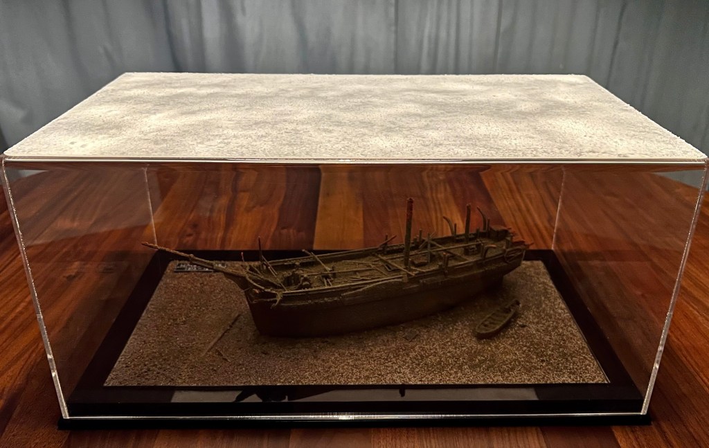
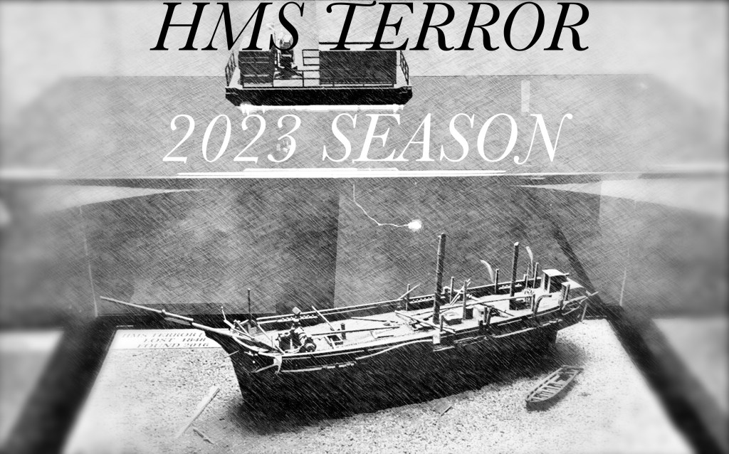
I recently wrote “Could I contemplate a scenario where new information would compel me to get back to work revising my Terror diorama?”1 Well, that situation happened almost immediately! In this post, I focus on what may seem a minor discovery – HMS Terror’s 1845 screw propeller. I argue that it is one of the outstanding finds at either Franklin Expedition wreck site. I will explore the history of this well-preserved artifact and situate it in a revolutionary program of naval ship design. I will conclude by showing how I incorporated the propeller into my diorama of the wreck site.

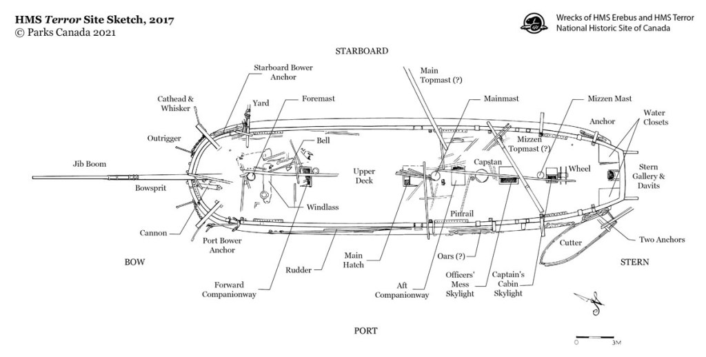
One hundred and eighty years ago, a visitor to Her Majesty’s Dockyard, Woolwich, near London, would have been treated to a memorable sight: one of Queen Victoria’s warships – under refit to explore the Arctic – was up on the stocks in dry-dock. This was one of a pair of bomb vessels (a type of specialized mortar-armed bombardment ship) which had been converted years before for polar missions. These tough ships had more than proved their mettle during James Clark Ross’s wildly successful expedition to Antarctica. Now the duo – each painted in severe black with a broad white strake stretching along the hull – had been selected for a new “Discovery Service” mission, to be commanded by Sir John Franklin: Complete a Northwest passage across the top of North America. Walking around the dock to the ship’s stern, that visitor would have seen something unusual: a strange cavity low down at the swollen stern post. This was just inboard from an enormous rudder. The hole opened clear through to the other side, like some casemated gun embrasure. Set into this void was a metal monstrosity: A cylindrical shaft with two broad blades twisting away from it. The visitor may have recognized this as a screw propeller – a marvel of the age. When coupled by a long shaft to a steam engine mounted in the bowels of the ship, the rotating screw could propel the vessel – all without a single sail of the lofty three-masted rig drawing a favourable breeze. If that same visitor had returned later, they may have felt the dupe of some trick: the machinery could have completely disappeared, leaving the man-sized hole. As if by some further sleight of hand, the whole cavity could have also appeared closed up, with only a faint rectangular outline now in evidence. What category of navy ship was this anyways? A sometimes-steamer with a propeller that unscrewed right off?! Indeed, here was something completely new: The first auxiliary screw-propelled polar exploration vessel!

The propeller, lowered and possibly installed in its aperture at the stern of the HMS Terror wreck, as photographed by the Underwater Archaeology Team during the late summer of 2019. Credit: used with written permission of Parks Canada, who retain copyright. Scroll down to the next page to see my model of this area.

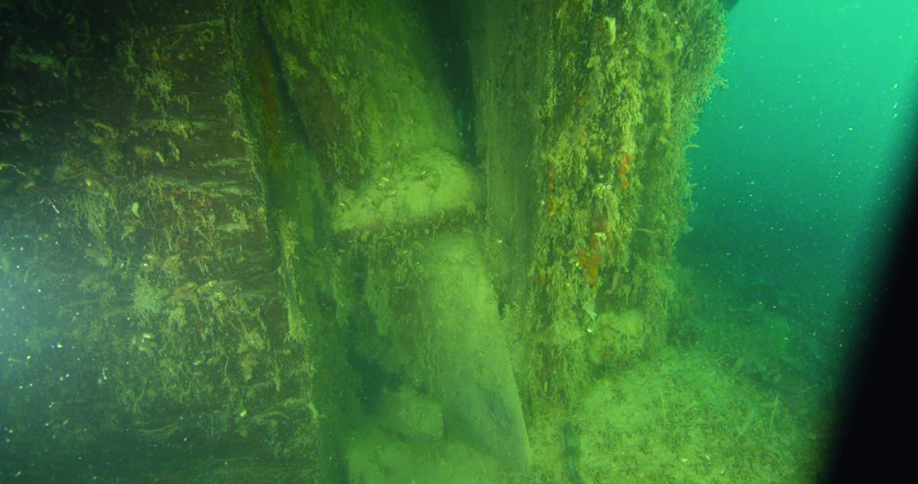
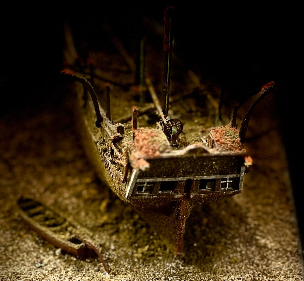
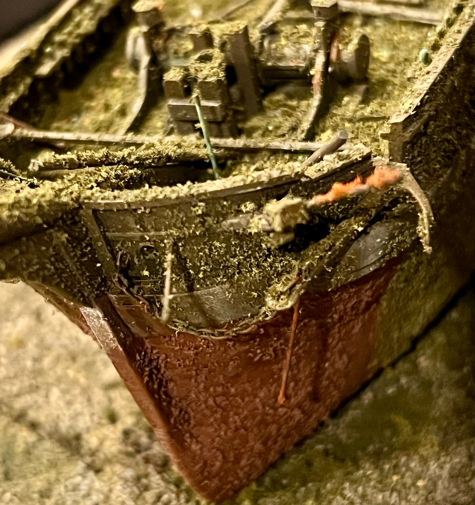
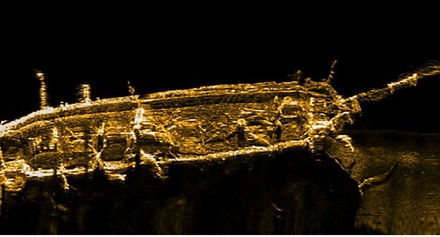
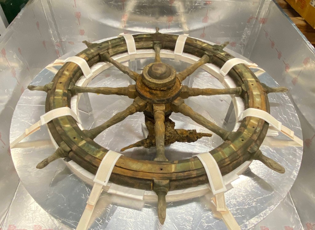
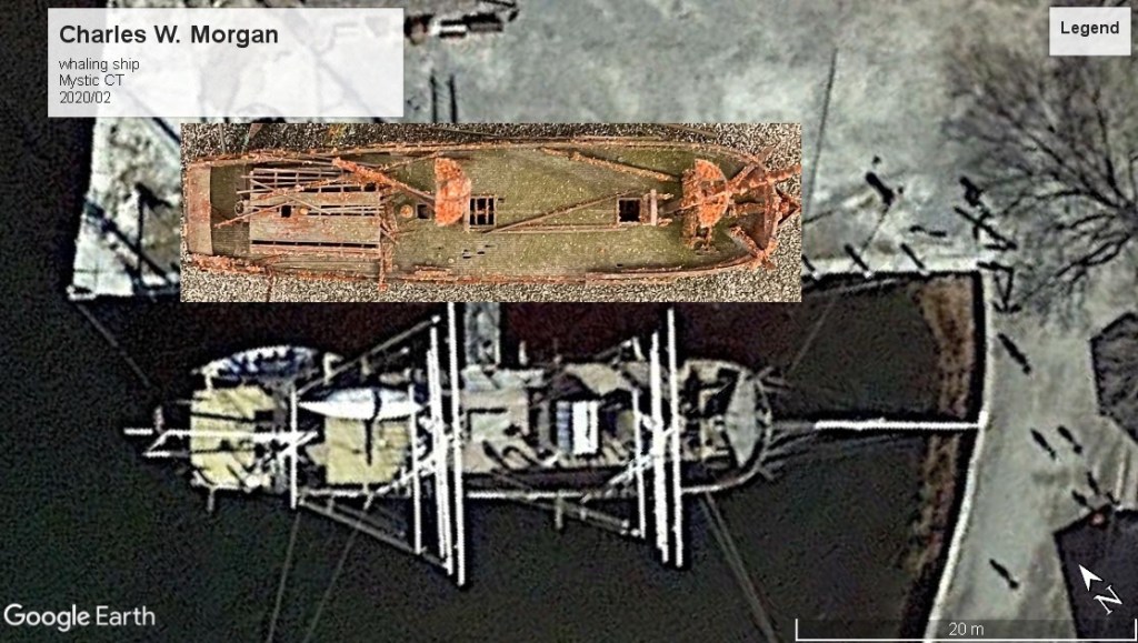
Early this year I was searching for information about the 2024 Parks Canada program of archaeology on the Sir John Franklin shipwrecks, HM Ships Erebus and Terror in Nunavut, Canada. Instead, I stumbled upon a new post “Anchors and Propellers” by Franklin Expedition scholar and veteran searcher David Woodman on his site: Aglooka.2 This update assembled interesting information about the ships’ complement of anchors, and also their propellers. Reading on, I encountered a previously unpublished image from the Parks Canada Underwater Archaeology Team (above). I was stopped dead in my wake! Here we see Terror’s screw propeller, installed in its aperture! With this photograph, we have the first visual confirmation that a marvelous piece of Victorian maritime technology has survived relatively intact after more than 175 years of immersion at Terror Bay.3

This simple two-bladed screw is one of the most important artifacts existing at either Franklin shipwreck site. The Commemorative Integrity Statement relating to this National Historic Site of Canada specifically identifies the marine screw propulsion as a character-defining aspect of the sites, demonstrating the 1845 technological innovation of the Expedition.4 From the waterline up, both ships looked much like they had during J.C. Ross’s expedition to Antarctica (1839-1843). Erebus and Terror were also not the first ships with an auxiliary steam engine to go north: In 1829 Ross’s uncle, Sir John Ross, had taken Victory north with an experimental – and mostly useless – steam engine.5 However, the idea of fitting a removable screw propeller into a Discovery Service exploration vessel was truly original. The suggestion came from a superstar in polar exploration. As Dr. Matthew Betts relates in his book HMS Terror – The Design, Fitting and Voyages of the Polar Discovery Ship, the seasoned Arctic explorer Sir William E. Parry – who now had an official role in investigating the optimal methods of steam propulsion in the Royal Navy – believed that the new propulsion technology could give vessels operating in the Arctic Archipelago a big advantage: The ability to navigate tight passages free from any dependence on the vagaries of the winds.6 Having auxiliary steam propulsion available to the Expedition captains could help force a constricted passage, position the vessels to better meet the rigors of overwintering in ice (for example by allowing them to get to a safe harbour or a more sheltered section of coast), or get them clear of an immediate hazard, such as an errant iceberg or a perilous lee shore. Parry’s experience commanding similar vessels in the Arctic provided him with an invaluable perspective on how screw propulsion could support this new attempt to transit the Northwest Passage. The Admiralty endorsed Parry’s idea.

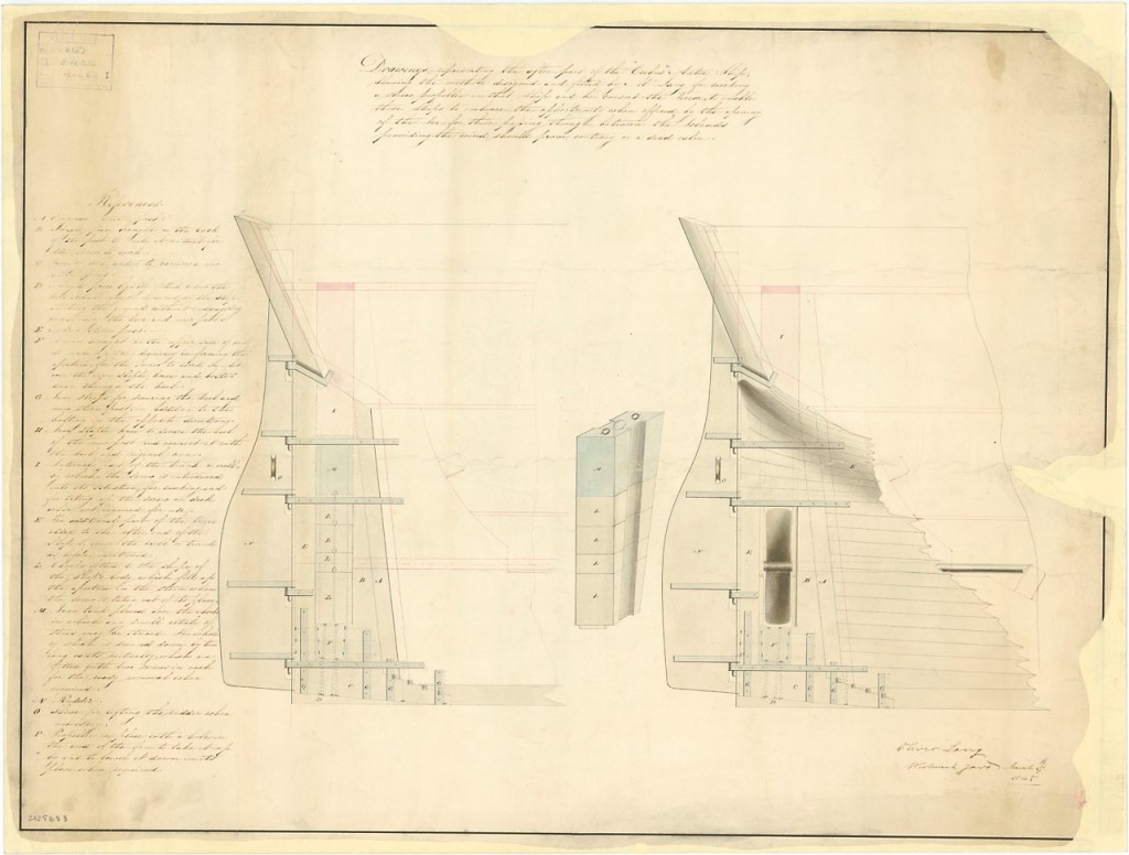
Oliver Lang, Master Shipwright at Woolwich, was responsible for working up a technical plan to meet this new requirement. A half-century after he had begun drafting designs, he remained at the forefront of marine technological innovation. During the early 1840s, the military strength of the Royal Navy still rested on the line of battle ships of the sailing navy, those wind-powered “wooden walls” whose broadsides of cannon had allowed Great Britain to dominate the World’s sea lanes. Lang applied new technologies to both mercantile and Royal Navy vessels. He strengthened the basic structure of warships, packed their hulls with new innovations, and enhanced crew comforts onboard, especially to improve lighting and circulation of air. His innovations helped equip the fleet with larger, stronger, and safer warships. He had recently turned to incorporating steam technology into his designs. There had been experiments with steam engines and, since the early 1820s, some small naval units had been propelled by paddle-wheel. The Admiralty was conducting a series of trials of steamers to test a variety of newly-designed screw propellers against paddle-wheel propulsion.7

The famous trial of H.M. Steam sloops Rattler and Alecto, 3 April 1845 (artist unknown). Rattler (left) displays Lang’s newly-installed mizzen mast. PAH0923 Credit: National Maritime Museum, Greenwich

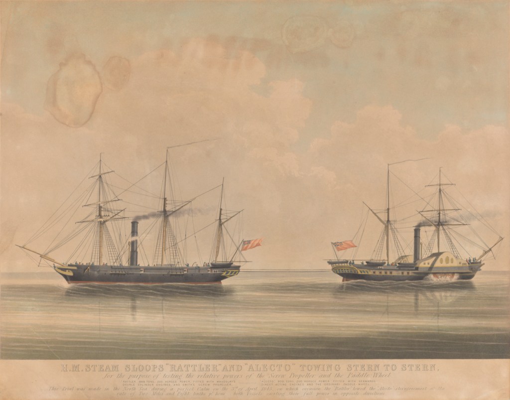
Lang’s own treatise Improvements in Naval Architecture (1853) is an important source for understanding his remarkable career. In his own words he “Arranged and fitted the first SCREW propeller to ship and unship in a TRUNK, so as to be taken up on deck in the ships “Erebus” and “Terror” on the late Arctic Expedition for Sir John Franklin.”8 The years 1844-46 were a busy period for Lang, which saw him embark on an ambitious campaign of propeller experimentation, design, and installation. He had first improved upon Rattler’s recently-installed propeller by re-rigging this steamer with a new mizzen mast, which could be used to lift the propeller in its frame straight upwards through a slot which communicated with the steamer’s weather deck. This allowed the crew to ship and unship the propeller, without specialized dockyard facilities.

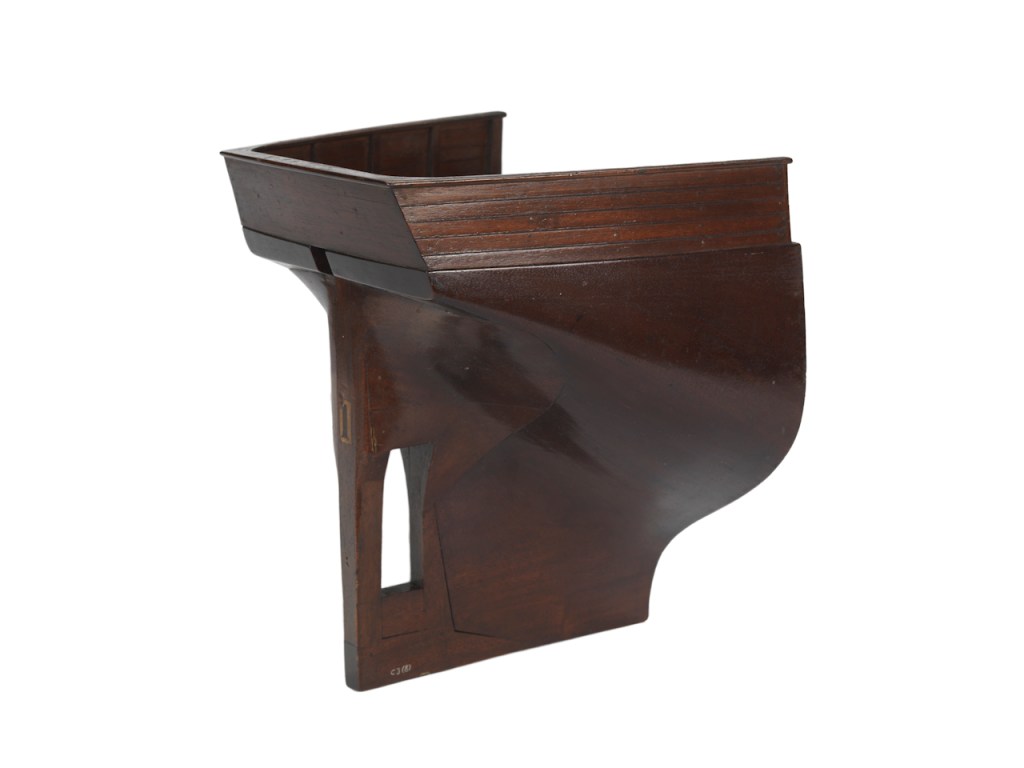
While building the large steam frigate HMS Terrible (1845 – fitted with paddle wheels), he moved on to designing and fitting his first complete naval propeller assembly. HMS Phoenix (1832) was modified from a paddle-wheeler to a screw steamer. Most of the essential elements of a Lang screw-fitted stern were now in place: propeller aperture, screw propeller, false stern or rudderpost behind the sternpost, a passage for lifting the screw upwards to the weather deck, and the means for lifting it out. The modifications to the Phoenix were underway when he got the “rush order” for the work on the two Northwest Passage exploration vessels.9

March 1845-dated plan of the modifications to the stern of both HMS Erebus and Terror, showing the massive rudder and stout construction. At left the screw propeller is raised and the full chock fills the aperture, while at right the simple two-bladed screw is installed and connected to the shaft which leads forward to the railroad steam locomotive that was installed in the hold. © Crown copyright. National Maritime Museum, Greenwich, London ZAZ5683, CC BY-NC-ND

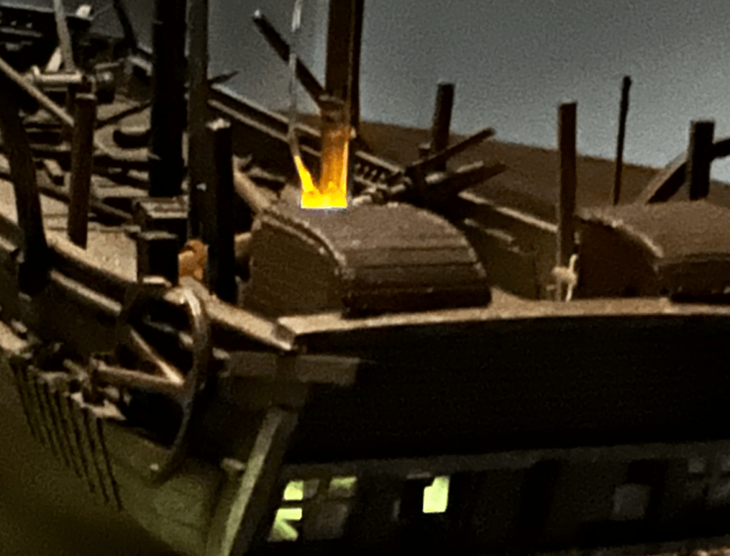
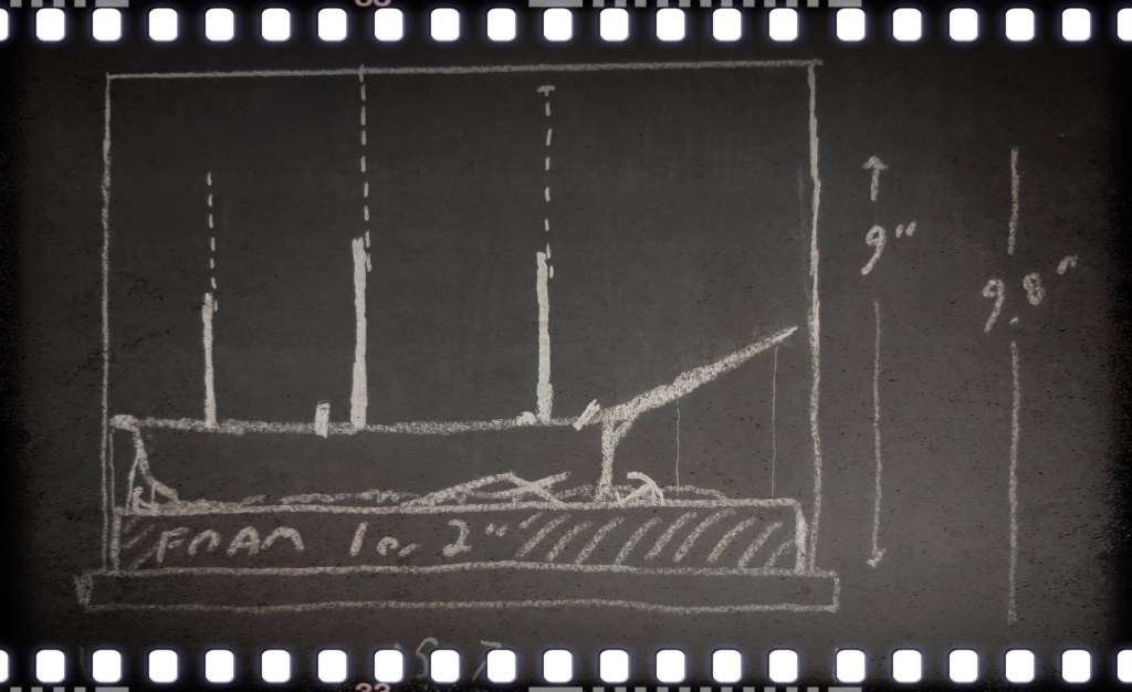
The main difference in modifying Erebus and Terror with auxiliary propulsion (with much less powerful steam engines converted from railway locomotives) was that the screws would only be fitted during occasional steaming, and chocks would fill each ship’s propeller aperture most of the time. This filler needed to streamlined into the lines of the hull to not weaken a vulnerable area, and to continue to guide the flow of water aft to the rudder. Lang’s other designs had the propeller fitting into its own iron frame, with the entire assembly lifted through a narrow passage to the deck, or lowered back in place. Erebus and Terror, by contrast, had rails that guided the propeller, which was lifted on its own.

A model of the stern of the Arctic ships as modified by Lang in 1845, showing the propeller aperture, and the bracing of both the stern post and new rudder post to permit the propeller to be hauled up into the trunk and on deck. A view from above shows the almost square passage for lifting or lowering the screw and installing the chock, and the smaller opening for the head of the rudder. Like at the wreck-site, the enormous rudder that would normally project aft is absent. SLR2253 Credit: National Maritime Museum, Greenwich, London.

Phoenix was ready in February 1845, and Lang moved to the design of HMS Niger, which would go on to be used in a more balanced round of evaluations of screw-versus-paddle propulsion (with Niger and Basilisk a closer match than Rattler and Alecto had been). During April, the Franklin ships were modified with their unique combination of adapted railway steam locomotive – installed deep down in the after hold – and auxiliary propeller. Woolwich dockyards had its own highly specialized engineering facility – the “Steam Factory” – with the equipment and docking slips to install the new steam systems. Lieutenant Henry T.D. Le Vesconte of HMS Erebus provided a contemporary description of the work. Writing to his father on 2 April 1845 – after he discussed the excellent prospects for promotion that would come his way by serving with the Franklin Expedition – he noted: “The ships are at present in dock where we are rigging each and stowing them while the shipwrights are altering their sterns by bracing on abaft the stern posts an large mass of timber of the same thickness in which to work the screw propellers the engines will be put in next week[…].”10 After the engines and propellers were tested, and the ships finished provisioning, the Expedition departed from Greenhithe, 19 May 1845. (Continue to explore Terror’s screw propeller on the next page)

Launching a Sad Little Boat Model

What if we could rebuild the “Boat Place” Franklin Expedition boat from its wrecked and scattered remains? In this post I will show my efforts to reconstruct the important boat I explored last week, at the same small scale as the HMS Terror wreck diorama.

The 2.4″/6cm long model on its sledge. Credit: http://www.warsearcher.com

In early 2025 I set about transforming a tiny plastic model to represent the boat and sledge that searchers looking for the lost Sir John Franklin 1845 Expedition came across in 1859 on the western coast of King William Island.1 My research is summarized in the “design dossier” section of my recent post on this discovery. Stages of my build resembled some of the real modifications ship carpenters would have worked at early in 1848, as they prepared to desert HM Ships Erebus and Terror – I sawed off the old square transom (visible in the below photo) and reshaped a sharp or rounded stern using Milliput putty around a balsa wood carved-out form (later removed), and built a new curved sternpost. I added two gudgeons, on the chance that the boat could have been fitted with a rudder. As of this writing, I believe the converted boat was based on the hull of the lighter 25’ Cutter instead of the Pinnace (see below boat dimensions section for detailed information).

The model boats. The sharper and narrower whale boats are 30 scale feet long. The original square transom of the model appears beside the two-dollar Canadian coin. Credit: http://www.warsearcher.com

I modelled the stanchions (the two posts rising out of the hull painted two-tone black and white) to be high, with gaff jaws at their tops (as described by Lt. Hobson). Some practical tests with the model revealed that the pronounced list observed in 1859 meant that, in order for Hobson’s team to have spotted anything emerging from the high drifts of snow, that stanchion would have to be significantly taller than represented in most reconstructions. With its gaping jaws open to the sky, it must have appeared a grim marker, indeed!

The model and sledge with a list down to starboard, buried in a drift of snow in my backyard. Credit: http://www.warsearcher.com

I decked over the bow and stern areas based on the Durand-Brager illustration (seen in the last post). The internal layout is similar to the whale boats that the ships carried. I like to think that the crews had a space in each boat to shelter an exhausted or ill member. A foredeck and covered stern sheets may also help explain the decade-long survival in decent condition of some of the artifacts that Hobson and McClintock discovered in the boat.

The gunwales were drilled for the thowells – tiny metal rods. I believe there was no washstrake boards, so I spaced the twenty-four thowells to support a washcloth that wrapped around the hull between the posts. Hobson noted these thowells (National Maritime Museum artifact AAA2143) were doubled up to assist the paddling. I paired them to create four rowing positions a side, and ran a rope along the top of the thowells, which the washcloth would have been rove into along its top edge.

The awning, and “cutaway” view. It is also possible that the awning connected directly to the gunwales, and not to the tops of the stanchions, which may not have been fitted while sledging on land. Credit: http://www.warsearcher.com

Artifacts currently placed in the model hull include six modified oars (cut down with add-on blade extensions), the sheet block (AAA2198), the folded-up lead sheets (AAA2280), and some sailcloth that could be the awning or the washcloths (AAA2144). Basic pieces of boat equipment, such as two masts, and a rudder, have never been found. I have added a mast step amidships, in case information or evidence of these details turn up. When under sail, the boat would likely have carried lugsails on its two masts.2 I hope someday to model the ice grapple/anchor encountered by the searchers. The bewildering assortment of personal items, cutlery, packets of chocolate, and human remains have not been represented.

The model takes to the water. Credit:www.warsearcher.com

This boat and sledge combination may look unwieldy, especially when compared to the supremely well-adapted Inuit equivalents: animal hide boats (Umiaks) on sledges built of lightweight organic materials. But in 1859, Francis Leopold McClintock – a masterful long-distance sledge traveler – seems to have been impressed by the lost crews’ efforts at lightening it.

As with so many of the specifics about the 1845 Franklin Expedition, we continue along our own voyages of discovery. This is not the first interpretation of the Erebus Bay boat, nor will it be the last. I have created a sad miniature of that “melancholy relic.” [Read more in the Appendix below for technical info about the boats and sources]

Appendix-JC Ross (1839) and Franklin (1845) Expedition boat types and sizes and notes:

The Great Terror Wreck Repair[2025]

A basic principle of model shipwreck archaeology is that – in contrast to their full-size brethren – model shipwrecks do not necessarily deteriorate. In this post we explore updates to our miniature interpretation of HMS Terror’s wreck. The Terror mini-site has witnessed substantial improvement since 2022!

Terror’s rebuilt stern, with new rudderpost, gudgeons to hang the absent rudder, a broader stern tuck up to the sternlights (windows) and lower water-closet deckhouses aft of the double wheel.

An earlier post “Wrecking the Terror: Recreating an Epic Tale of Old Loss and New Discovery” summarized what we know about the actual wreck of HMS Terror located in Terror Bay, Nunavut, and my 2022 project to build a small diorama of the wreck site. Terror, an astonishingly well-preserved time capsule of the last Franklin Expedition, continues to captivate Franklin scholars and enthusiasts, archaeologists, naval historians, ship lovers, and the expanding fandom community who continue to enjoy the fictionalized drama of AMC’s “The Terror”(season 1).

HMS Terror site sketch, 2017 copyright Parks Canada 2021 [modified by rotating]. Source.

Turning now to the reduced-scale World, Terror was my first wreck diorama, and was followed by Breadalbane High Arctic shipwreck and HMS Ontario.

A “glass-bottomed boat” view of the updated wreck site, 80 scale feet under the acrylic case top. The shadow of the bowsprit points due north.

Two years after I thought the diorama was complete, I decided it was time to open the case up and revise some features. A sketch I had worked up independent of this project also helped motivate me to rebuild the Terror.

So what changes has the miniature site undergone? The entire lower hull was reshaped to better highlight the turn of Terror’s bilge, the overall body lines, and the broader aft quarters. The wreck was also placed at a more pronounced list to starboard. I added more detail to the debris of fallen masts and yards now located on the upper deck, which better interprets the complexity of the three-masted barque-rig and the chaotic event of the sinking. This “top-hamper” – and what appears to be the ridge poles of winter awnings – would have showered the deck and areas immediately adjacent to the hull with the types of debris we see in the site plan released by Parks Canada, and imagery released by their Underwater Archaeology Team.

The weather deck looking forwards from the taffrail.

Under all the accumulated silt and growth, there is likely to be a bewildering variety of artifacts, which my interpretation can only begin to hint at. The ship’s boat off the port quarter of the wreck was given a modest update: A more accurate fallen davit resting across the stern.

The bows including the port bower anchor, the hawse holes, the catshead with whisker boom, and other oddities of the polar-modified bomb vessels. under the reinforced channels, the massive ice shield of iron plates shows corrosion and marine life.

The water-closet structures at the stern were completely rebuilt with lower roofs and sliding doors opening to the sides. They still have detailed “privy” interiors. A small cavity at the aft end of the starboard closet shows where the flag locker was located.

The new stern water closets, the double wheel and the captain’s skylight just forward of that. In the foreground, a pipe leads down to the captain’s small stove.

The interior of the wreck diorama remains practically inaccessible, and no substantial work was done belowdecks during our “great repair.” I do hope that, in a future season of modelling work, a more fulsome recording of the detailed interior spaces of the model could be attempted. For now, we had a quick examination of Capt. Crozier’s miniature great cabin through the stern windows; his captain’s desk remains in place, but the drawers are still modelled tightly shut. No miniature records have yet been recovered.

Light shines down through the captain’s skylight onto the surface of Crozier’s desk.

Those with keen eyes will note that the team of scuba-diving archaeologists have not been reinstalled in their customary positions. The site is currently under ice and snow, and they will not return to their program of scale archaeology until the next dive season commences in August, 2025. Could I contemplate a scenario where new information would compel me to get back to work revising the Terror diorama? You bet your sextant I could!

The diorama with its winter cover of ice and snow.

Rise Again Terror Boat: The Surface Needs You!

Raise the Terror…NO! Raise the HMS Terror’s Boat! Why? Read on!

A year ago we “floated” the idea of raising an important artifact of the lost 1845 Sir John Franklin Expedition, from one of the two incredible shipwrecks at the Wrecks of HMS Erebus and HMS Terror National Historic Site: A ship’s boat from HMS Terror. In the intervening months, we have bulked-up on our boat-raising research, and have circled back to this topic. We’re doubling down: the World NEEDS the Terror boat back on dry land.

A simulated underwater archaeologist contemplates raising the 1/125 scale model boat wreck on our diorama of the wreck site of HMS Terror. Credit: www.warsearcher.com

During September 2024, Parks Canada underwater archaeologists were again on site in Nunavut, in the high Canadian Arctic. They were conducting an archaeological program at the extraordinary shipwrecks of HM Ships Erebus and Terror. Early indications suggest that they had a long dive season! We are very much anticipating the release of information about newly-recovered artifacts and other discoveries.

There is an artifact that we hope someday will be recovered: one substantially intact 23-foot/7m ship’s cutter. The boat was pulled down as Terror sank in a bay along the southwestern coast of King William Island later named, by coincidence, Terror Bay. Lost about 175 years ago, it has, like the rest of the Terror site, remained astonishingly intact, 80’/14,4m beneath the freezing waters of the Bay.

HMS Terror site plan, ca. 2017, available online as of late 2021. The boat is marked “Cutter” at lower right. Credit: Parks Canada source.

In the earlier post, we explored the idea that this important artifact could be raised from its location on the seabed off the port quarter of the Terror hull (the same caveats still apply).1 The boat wreck could then be conserved and stabilized for eventual public exhibition. Visitors would be able to engage with a remote National Historic Site of Canada by interacting with a substantial Franklin Expedition artifact. We also proposed that it could be replaced with a wooden replica, carefully deposited in position back at Terror Bay. This replica boat would replace the original at the wreck site: It would aesthetically preserve the integrity and character of the site; it could also help monitor changes to the seabed environment that may be less apparent on the original wreck structures; and it could provide powerful commemorative options for an in situ memorial, that would remain, marking this important site for generations to come. Why not have a memorial boat serve as a submerged cenotaph, with plaques in three languages – English, French, Inuktitut– to commemorate the lost 129 men of both the Erebus and the Terror?

This sunken cutter is the only boat from either ship that has survived the destruction of the Expedition in any semblance of its original condition. It would be a signature object around which to build commemorative and interpretive programs. After treatment, it could be placed on display at the Nattilik Heritage Centre in Gjoa Haven, or another suitable museum.

The Nattilik Heritage Centre, Gjoa Haven, taken during a visit from Adventure Canada cruise members in 2019. The Centre houses many interesting artifacts, and the exterior nods to both Inuit and explorer traditions. Credit: Kerry Raymond, CC BY 4.0 https://creativecommons.org/licenses/by/4.0, via Wikimedia Commons

There was an era in underwater archaeology when raising a wooden artifact that had been immersed for any length of time was a recipe for destroying it. Sunken wood becomes saturated with water molecules, and swells. This alters the original properties of the wooden structures. After it is exposed to air and dries out, the artifacts become fragile to the point of crumbling. During the 1960s, starting with the famous archaeological work on the Vasa warship wreck in Stockholm Harbour, conservators learned to treat wood and metal artifacts with Polyethylene Glycol (PEG). This compound can replace the water content in the wood, to help it retain its basic dimensions and structure, and allow it to be stabilized for long-term preservation.

The Vasa’s treated hull at right, with a ship’s boat at lower left, and a large-scale model at upper left, all on display at the Vasamuseet, Stockholm. Vasa was found to be carrying three boats, including this 38’/11.7m elbing boat, recovered from the 105’/32m seabed. Credit: Pierre Goiffon via Wikimedia Commons.

The success of a project of this importance would depend on securing an elite team of archaeologists and conservators. The good news is we did not have to look far afield! The archaeologists currently working on the wrecks – Parks Canada’s Underwater Archaeology Team (UAT) – have some of the most relevant expertise in the World at successfully completing exactly this type of project. They have surveyed, disassembled, conserved, and reassembled sunken boats from National Historic Sites of Canada – and they’ve done an incredible job. During the late 1960s Parks Canada was an early adopter of PEG treatment to help conserve raised boat wrecks.2 Since then, they have tackled larger and more complex projects.

This and the other volumes in the edited multi-volume Parks Canada series show the ambitious archaeological project at Red Bay Labrador. The project is the major precedent for the current work on HMS Erebus and Terror (Cover illustration by Carol Piper). For full citation see endnotes.

At the Red Bay National Historic Site, Labrador, the remains of a 90-foot long, 250-300 ton Basque whaling ship, usually identified as the San Juan, were methodically excavated from 1977-1992. A thrilling discovery was made in 1983 under the timbers at the stern of the 16th Century shipwreck: The remains of a well-preserved chalupa-type whaling boat. The whaling boat is believed to have been dragged under at the moment of the shipwreck, in a similar manner to Terror’s cutter. The project was extensively described in a multi-volume publication by Parks Canada.3 It was a remarkable find – a missing link in the development of whaling boats and a Basque precursor of North American-built settler and indigenous whaling boats. After meticulous planning and preparations, the decision was taken to raise the remains of the four-hundred year old vessel to reassemble it. An article by Charles Moore, a leading Parks Canada archaeologist, and a piece on the Parks’ website – “Archaeology of a Sixteenth-Century Basque Whaling Boat” – describe this work.4

The Parks Canada conservation laboratories in the south of Ottawa, ca. 2023. Credit: http://www.warsearcher.com

The recovered timbers were shipped to Ottawa, stabilized and treated with PEG, and then painstakingly reformed and reassembled in Parks’ conservation facilities. In July 1998, after a nerve-wracking drive back to Labrador, the 26-foot boat was placed on display in a new interpretation centre back in the community of Red Bay. Today, the artifact continues to offer visitors an accessible connection to the history of Basque whaling in North America, and the National Historic Site under the adjacent waters of Red Bay. A chapter of Parks Canada’s multi-tome series on the Archeological program and discoveries of Red Bay, written by archaeologists Ryan Harris and Brad Loewen, documents the UAT’s meticulous efforts to survey, excavate, raise, and reconstruct this boat.

Reconstructed Chalupa 16th Century Basque whaling boat raised from seabed by Parks Canada and conserved at the Red Bay National Historic Site Credit: Magicpiano, CC BY-SA 3.0 https://creativecommons.org/licenses/by-sa/3.0, via Wikimedia Commons

It was especially challenging to extricate this boat from the whaling ship remains: the chalupa had been crushed by the bulk of the San Juan’s stern and flattened later by collapsing ship timbers. It was also sandwiched between articulated wreck elements. Terror’s cutter, by contrast, appears to be substantially intact and disassociated from the main site. Indeed, from the above site plan, and Parks Canada photos and film, it appears to be sitting pretty, filled with protective sediment and lightly embedded in the muck. What worked for the Red Bay site during the 1990s can now work for Terror Bay in our years. Raising the boat could be the type of tantalizing project that would sustain popular enthusiasm for the meticulous archaeological investigation of both sites over the coming decades.

The preserved artifacts mentioned in the text and notes of this post have all become prestige objects to build museums, visitor centres, and collections around. This is what we would wish for the Wrecks of HMS Erebus and HMS Terror National Historic Sites of Canada. It does feel like it is time we start talking about raising the Terror’s boat.

A simulated underwater archaeologist has been convinced about raising the model boatwreck on our diorama of the wreck site of HMS Terror. Credit: www.warsearcher.com

Rise again, rise again, that her name not be lost
To the knowledge of men. We’ll make the Terror ship’s boat rise again! [paraphrase of Stan Rogers’ The Mary Ellen Carter]

We asked a year ago and are asking again: Have we convinced you? Let us know in a comment!

REFERENCES

The Terror we Wish we Knew

HMS Terror, Sir John Franklin’s second exploration vessel, was discovered in Sept. 2016. Captain Francis Crozier’s sturdy little ship had vanished seventeen decades earlier. HMS Erebus, the flagship of the lost 1845 expedition, was located in 2014, about 70km south. Franklin’s mission was to have taken them into uncharted waters, to finish surveying a Northwest Passage across the top of North America. Where they went, none could follow.

So many questions about Terror and her lost crew remain unanswered. Archaeology on the incredibly well-preserved wreck is still in the early stages. The yearly dive season is all too short – late August to mid-September on a good year. Underwater Archaeologists are up there right now (2023/09).1 See our earlier post for possible Terror-related archaeological priorities. Here are some questions we have about this fascinating shipwreck:

A. When, why, and how did Terror actually sink? How did Terror get from the point of original Apr. 1848 abandonment by Crozier and the crew, Northwest of King William Island, to a resting spot under the waters of Terror Bay?

B. What documents or artifacts are in the great cabin desk? What other objects are along the shelves there? What is in Capt. Crozier’s bedchambers (behind the only blocked door on the lower deck)?

C. Is Terror’s screw propeller deployed in its trunk, or raised up? Since we know the massive rudder is unfitted and mounted on the ship’s port side channels, this info could help understand Terror’s last movements near Terror Bay, King William Island.

March 1845-dated plan of the modifications to the stern of both HMS Erebus and Terror, showing the massive rudder and stout construction. At left the screw propeller is raised and the full chock in place. © Crown copyright. National Maritime Museum, Greenwich, London ZAZ5683, CC BY-NC-ND

D. What did the stern gallery (windows at stern of ship) really look like and was there any transom decoration?

E. What else is on the seabed, besides the 23-foot ship’s cutter (boat) off the port quarter. The original Arctic Research Foundation 2016 wreck discovery film showed a variety of weird and interesting objects on the seabed.

F. How high do the remains of the masts project above the weather deck? We know the foremast is entirely missing (most likely on the seabed under the bowsprit – see link to last post’s multibeam sonar video clip)

G. Since the wreck and debris are highly localized, are there any significant timbers or structures missing, that suggest damage or removal by the crew?

H. What condition are the lowest decks in? How much provisions and fuel remain aboard?

I. Are there any human remains on the ship? (either the wreck is a tomb to members of its crew, or it is a powerful site of remembrance of those departed explorers)

It’s seventeen long decades since these ships of fame
Brought my Lord Franklin across the main,
To Baffin Bay where the whale fish blow
The fate of Franklin no man may know.
(Adapted Lady Franklin’s lament trad.)

  1. Early indications suggest the balance of September 2023 archaeology has again prioritized Erebus. ↩︎

An Excellent State of Terror Now Exists

“Who knows what lies behind that closed door!” (R. Harris, Parks Canada, 5 Sept. 2019) As this year’s underwater archaeological season commences on the Sir John Franklin 1845 Expedition shipwrecks, HMS Erebus and Terror, we highlight what we believe to be an important description of the incredible condition of the shipwreck of Terror, discovered September, 2016.

Model diorama we constructed during 2022 which was inspired by the sources of information discussed below.

The most detailed public statement regarding the condition and archaeological plan for HMS Terror that we are aware of remains Ryan Harris’s 5 September 2019 comments to visitors onboard Parks Canada’s Research Vessel, David Thompson.1 It is an authoritative and concise description of Terror, from an experienced underwater archaeologist who has significant dive time on both Franklin wrecks. (There is more context about the vessels mentioned in this post from our 2022 update)

Ryan Harris (left), Parks Canada project lead, alongside Prime Minister Stephen Harper (center) and Minister of the Environment Leona Aglukkaq, announcing the discovery of HMS Erebus 9 Sep. 2014 [cropped]. Credit: Jason Ransom Library and Archives Canada R16093-50252-9-E.

Harris was recorded by Adventure Canada crew members or passengers during the first (and thus far only) visit of members of the general public to the Wrecks of HMS Erebus and HMS Terror National Historic Site. This was included in a remarkable video with other clips featuring Marc-André Bernier, veteran underwater archaeologist, and other Underwater Archaeology Team (UAT) members. Site sketches and multi-beam sonar of both wreck sites made jaw-dropping cameo appearances.

A sonar image of the HMS Terror wreck, ca. 2017, which was similar to one of the images in the film. credit: Parks Canada, Crown Copyright source.

The film was uploaded to the company’s YouTube account and was also featured in Bunny Laden’s blog post “A Visit to the Wrecks of the HMS Erebus and HMS Terror National Historic Site of Canada” released on Adventure Canada’s site eleven months later. The lucky participants from the Northwest Passage cruise onboard MS Ocean Endeavour had been able to board the dive support barge, Qiniqtiryuaq, which was anchored near the wreck of Erebus. They also explored David Thompson. Harris spoke candidly about Terror, and also the plans for the 2020 archaeology season. After the heady days of 2019, events (The Covid-19 Pandemic and an increasing concern about Erebus’s fragility) caused the postponement of these best-laid plans. Rumours have circulated that this year’s archaeological season, which appears to have started, may involve a significant return of the archaeologists to Terror.

1927 Gould Admiralty Map, which listed Franklin-related discoveries and conjecture about the ships up to that time [modified with several updated locations, including the approximate wreck locations and geographic features]. Credit: Library and Archives Canada May Fluhmann fonds MG31-C3 vol.1

Harris’s statement is important, so we transcribed it to the best of our ability, and encourage readers to visit the hyperlinks to see what he was referencing:

This is another multibeam image that we collected just a few days ago in Terror Bay. This is the other ship, HMS Terror, and you can probably readily see that this is in really really good condition, even better than the Erebus. It’s essentially completely intact. So it has all kinds of structures sticking up, including davits, these suspended the various boats, and raised and lowered them over the side. We still see masts standing to a certain height, sheared off about 10 feet in the case of the mainmast, above the deck. And along the centerline are various openings in the upper deck, including the forward companionway down to the focs’l. (BREAK)

And those openings, even though they are sometimes skylights with all the panes of glass still intact, we’re able to insert that Remotely Operated Vehicle you may have seen on the dining room table here, into, on several different occasions, and we’ve explored 90% of the lower deck just a few days ago. If you have seen the Youtube video [link], a lot of that footage – some of the good stuff!

The only cabin or compartment we couldn’t access was Captain Crozier’s bedchamber. So tantalizing – behind the only closed door on the ship that we haven’t seen – so who knows what lies behind that closed door! But you peer down the corridor with the ROV and you can see the list of the ship, because the ROV rights itself naturally…and through the darkness you see the lights penetrating, and then a succession of cabin doors, all sliding doors all open, and we went in one after the other…probably twenty different times -every single cabin except for that one – open. And you could see an incredible array of artifacts all in situ, chamber pots below the beds, washbasins on the shelves, muskets attached to the wall ready for action, ceramics, the plates for the different mess groups, showing different ceramic patterns mess group by mess group…little cradles that are in the sick bay, which are the sick beds…just a wondrous array of artifacts that are going to be documented in the years to come.

So the plan for next year is to basically take that barge, anchor it over the Terror, and do the same thing but with the surface-supply diving equipment, the hats and umbilicals and we’ll go inside and we’ll go cabin by cabin and learn what we can.

Ryan Harris, Parks Canada, Adventure Canada 5 Sep. 2019 interview (loaded on Youtube).
A 2017 plan of HMS Terror wreck site released by Parks Canada and uploaded to their site in late 2021. Credit: Parks Canada, Crown Copyright source.

We hope that that plan comes to fruition in the next few weeks and that this is a productive season for exploring the always astonishing, barely-wrecked ship of wonder, HMS Terror!

  1. Another essential description of the wreck is the epilogue “The Discovery Vessel Herself Discovered” that concludes Matthew Betts’ recent book, HMS Terror; the Design Fitting and Voyages of a Polar Discovery Ship (Pen & Sword 2022). The authors of the foreword, Ryan Harris and Jonathan Moore, UAT Manager, note that Betts provides a summary of Parks Canada’s findings up to publication. ↩︎

Breadalbane Part 2: Finding a Shipwreck under the Ice at Beechey

This second post will focus on the 1980s discovery and explorations of the incredibly intact wreck of Breadalbane off Beechey Island, Nunavut. The first post summarized the loss of this supply ship in the High Arctic in Aug. 1853, while resupplying search expeditions looking for the Franklin Expedition. The third post shows our construction of an archaeologically-based scale diorama of this National Historic Site of Canada. A fourth post explores the wreck based on Parks Canada’s 2014 visit.

The Breadalbane wreck diorama, built in 2023, represents the wreck at a scale depth of 330’ as it appeared before its 1980 discovery. This will be the subject of a future post. Credit:www.warsearcher.com

On August 17th, 1984, Anthropologist Owen Beattie, looking for evidence of what went so terribly wrong with the 1845 Franklin Expedition, exhumed the body of John Torrington, a stoker from HMS Terror who had been buried almost fourteen decades before at Beechey Island, in the Canadian Arctic. Torrington had been one of the first to perish, on New Year’s Day, 1846. He was buried at the site of the first winter encampment of HM Ships Erebus and Terror. When photos were released of his body, newly exhumed from a frozen coffin, the public was shocked, fascinated, and a little horrified. This early-Victorian sailor appeared to have barely decayed!

John Torrington’s grave marker. This is a replica placed here in 1993 when the original marker was moved to the Prince of Wales Northern Heritage Centre. Credit: Gordon Leggett via wikimedia commons [cropped and edited]

The state of preservation should not have been so surprising: remains and relics of Arctic exploration located at Beechey just don’t seem to deteriorate as we would expect! A few years earlier the wreck of the supply ship Breadalbane had been discovered nearby. Like Torrington and the shipmates buried alongside him, Breadalbane was also “Frozen in Time.”1

Map of the Arctic portion of North America, with the state of surveying just before the Franklin Expedition set off. [cropped and annotated with rough location of Breadalbane sinking] HM Admiralty; J. & C. Walker, Public domain, Royal Museums Greenwich via Wikimedia Commons

In most other bodies of water on Earth, a 130-year old wooden shipwreck would be a pile of debris and ballast stones, with scattered cannon, decayed timbers and remnants of cargo, copper and rusted metal left to hint at its past size and shape. The naval shipworm (toredo navalis – a pernicious little species of clam) devastates wood, devouring wooden hulls, masts, and deck structures within a dozen or so years. In the High Arctic, as in the waters around Antarctica, and a few inland lakes and seas, the shipworm has no dominion, and wrecks remain as silent sentinels of past eras of trade, warfare, or exploration.

As the lost ships and vanished 129-man crew of the Franklin Expedition lived on in the popular memory, the related story of the ship that sank at Beechey in 1853 was completely forgotten. During the 1970s, Dr. Joe MacInnis, a Canadian who was pioneering new undersea medicine and diving technologies, began looking into Arctic shipwrecks, with the idea of a search that could also be a test bed for new undersea equipment. Using archival sources from the Scott Polar Research Institute, the National Maritime Museum in Greenwich, and elsewhere, he eventually seized on the idea of a search for the Breadalbane. He had high hopes of locating the wreck based on the reasonably accurate statement about where the ship was lost south of Beechey Island. He led a multidisciplinary team, supported by Canadian Coast Guard icebreakers, starting in 1979. Weather and ice conditions limited the search to a few short weeks and the team was forced to wait to return to the waters off Beechey until August 1980. That year, they discovered a wreck in about 330’ of water, two kilometres south of the Island’s imposing cliffs.

Annotated Sentinel Playground image of the conditions around Beechey Island 165 years after the sinking, showing dangerous ice pans and floes south of Beechey. These conditions in mid-August both caused the original 1853 loss of Breadalbane, and made any summer search or exploration efforts on the wreck difficult.

While noting enormous iceberg scour trails snaking their way across the seafloor of the Barrow Strait, a clear image of a wreck came across the sonar print-out. The images were interpreted by expert sonar technician Garry Kozak on the bridge of the Canadian icebreaker CCGS Sir John A. McDonald. Surprisingly, the scans clearly showed two masts pointing towards the surface. They had located a large sailing ship! A sonar image, though, does not constitute a confirmed shipwreck identification. For that, the team needed “eyes on the prize.” That came soon after, as the team were able to descend a camera on a line to the wreck, which filmed some portion of the ship’s gunwales or deck.

CCGS Pierre Radisson (at right) refuels HMCS Moncton during the Sep. 2015 Operation QIMMIQ in Nunavut, related to the search for HMS Terror. Pierre Radisson was involved, early in her career, in the Breadalbane exploration. Credit: Department of National Defence (Corporal Felicia Ogunniya) SW2015-0226-1306

After delays and an unfavourable season, the team returned in September 1982 with a Benthos Remote Piloted Vehicle (RPV). This advanced robotic vehicle had been developed by Chris Nicholson, who was present to skillfully pilot it (Nicholson would be involved in many other robotic explorations, including on RMS Titanic and the US warships Hamilton and Scourge in Lake Ontario). The RPV captured a rich visual record that helped survey the wreck’s condition-it was shockingly intact! During April 1983 they were back over Breadalbane with more funding and an incredibly audacious plan that MacInnis had put together: To establish a camp on the ice over the wreck using flown-in supplies; to continue to survey the Breadalbane with RPVs; and to tractor in equipment to enable the team to perform crewed-dives to inspect the wreck and surroundings. The frigid depths the wreck lay at were beyond the limit of safe scuba diving or surface-supplied diving. The team had been planning for this. They would operate the WASP suit, a newly developed atmospheric diving suit that was safe to operate beyond Breadalbane’s depth. It was basically a heavy diving-suit-like one-person submersible, with claw-like hands emerging from articulated arms, a dome to look through, and a single lower section.2 The WASP pilots propelled themselves by marine thrusters.

The cover of the July 1983 edition of National Geographic showed the recovery of a WASP-suited pilot who had been exploring the wreck. The National Geographic photographer most involved in shooting some incredible imagery was Emory Kristof, longtime underwater photographer.

This might all seem standard procedure in the third decade of the 21st Century. Similar dives have now been performed on other Franklin Expedition-associated sites, and an ice camp was also an option in the recent find of Sir Ernest Shackleton’s exploration ship Endurance under the Weddell Sea, Antarctica; however, in 1983 this was pushing the limits of technology. Looking back at the concurrent RPV filming and diving, and the as-it-happens filming of a National Film Board documentary, directed by Bill Mason, the logistical and technological efforts in an environment of -20*C, and the “cowboy” atmosphere at the ice camp…the whole effort was bonkers!3 Somehow, the program stayed on track, and things came together just when they had to. The dives were an incredible success. WASP pilots Phil Nuytten (a Canadian engineer heavily involved in the design of the suits) and Doug Osborne have been the only humans to ever visit the site. Nuytten was quoted as saying ”It looked like you could sail it away, if you could somehow make the water vanish, you could probably repair it in a couple of weeks and sail it back to England. It looked great.”4

As Dr. MacInnis relates in his book on the topic, The Search for the Breadalbane, news of the 1980 Breadalbane discovery was eclipsed by false reports of the discovery of RMS Titanic, which would not actually be located until five years later (iconic bow section view). Courtesy of NOAA/Institute for Exploration/University of Rhode Island (NOAA/IFE/URI)., Public domain, via Wikimedia Commons

Compared to the barrenness of Beechey’s landscapes, Breadalbane was found to be host to thriving communities of marine life. Anemones and bright white basket stars blended with vibrant pink, orange and red coral growths on the upper hull and topsides. Everywhere there was silt, heaps of growth, and decades of deposited phytoplankton and algae, which floated down on the wreck like green snow. Below this abundance, her lower hull was found to be clad in a minty-green cloak of beautifully-preserved copper sheathing.

Copper roof sheets originally removed from the roof of the Canadian Parliament Buildings in Ottawa, now a wall in the lobby of the Canadian War Museum. These approximate the sizes and shades of verdigris on the Breadalbane’s hull. (Author’s photo)

A brief summary of the archaeological discoveries and major features of the wreck would highlight the exceptionally large and early example of a deckhouse. It survived mostly intact on the ship’s quarterdeck, and was packed with artifacts such as tables, chairs, and a ship’s stove. Elsewhere, deck furniture included the large windlass forward and the capstan aft. Open hatches provided glimpses of the chaotic damage on the lower deck. The ship’s wheel and a binnacle cabinet were located with navigating instruments, on the small after deck.

Site plan of Breadalbane as discovered in the early 1980s, drawn in 2023 relying on 1980s and 2012-2014 ROV and dive footage, sonar scans, artistic reconstructions, and other sources. Credit: http://www.warsearcher.com, who retain copyright

The lower hull was marked by a massive extent of ice damage, particularly running along the starboard bilge. This marred otherwise pristine copper sheathing. A well-preserved bower anchor of the stockless variety was discovered on the seafloor, on the Portside of the stem, with a heavy hawser still leading up to a hawsehole. The rudder was located on the seabed just aft of the sternpost, while the fallen mizzen mast stretched from it off to port. White draft marking climbed up the sternpost (these would have originally helped load, ballast, or trim the ship, filling it to a safe, even, waterline level). Debris and spars stretched along the port side on the seabed, with a railing, originally on the deckhouse roof, running like an angled ladder from the seabed to the ship’s sides. The bowsprit was shattered, the figurehead could not be discerned through the growth, and the ship’s bell (a focal point of any shipwreck) was not found.

A 1987 issued Canada Post 36 cent stamp commemorating the Breadalbane find, which shows the wheel with colourful marine growth. Credit: Credit: Library and Archives Canada; Copyright: Canada Post Corporation

During the 1983 RPV and WASP operations, a small number of artifacts, and notably the ship’s wheel, were brought to the surface. Parks Canada underwater archaeologist Robert Grenier did not support the recovery of items from the site – a process that requires additional permits and permissions. Once the objects were at the surface, he worked diligently to safeguard the preservation of these wooden artifacts and prepare them for transportation.

Forty years later, the wheel as preserved at Parks Canada’s Ottawa facility, May 2023. Credit: Russell Potter, Visions of the North blog: https://visionsnorth.blogspot.com/2023/04/a-visit-with-parks-canada-part-2-of-3.html?m=1

After the recovery, the team worked quickly to wrap up the season, tearing down the ice camp. The fabulously expensive equipment was shipped south. Joe gave interviews and presentations and wrote his book, The Search for the Breadalbane, Bill Mason produced the NFB documentary Land that Devours Ships, the National Geographic photo crew moved to other assignments, Chris Nicholson continued to design and operate improved robotic systems, and Garry Kozak was involved in new sonar searches for other famous shipwrecks. Robert Grenier returned south to continue the massive archaeological excavations at Red Bay, Labrador. When the last plane lifted off the ice-strip in the shadows of Beechey Island’s imposing cliffs, Breadalbane was again left as a time capsule waiting under the ice.

  1. John Geiger and Owen Beattie’s 1987 book Frozen in Time: The Fate of the Franklin Expedition laid out a hypothesis that lead poisoning had contributed to the destruction of the Franklin Expedition, which had originated out of the 1984 exhumation of Torrington, and John Hartnell and William Braine the next year. The grave of sailor Thomas Morgan, of HMS Investigator, located beside the three Franklin graves, has not be excavated. The author, as a young boy, first saw the Torrington image in Owen Beattie and John Geiger’s 1991 young readers book Buried in Ice: The Mystery of a Lost Arctic Expedition, and has been trying for thirty-two years now to unsee it. ↩︎
  2. Readers may recall a different type of atmospheric diving suit, the JIM suit, making an appearance in the 1981 James Bond film For Your Eyes Only. ↩︎
  3. The NFB film “Land that Devours Ships” (1983) is an incredible visual record of these expeditions to the Breadalbane, that can be fully viewed on the NFB website. The author would like to acknowledge the continued assistance of Jonathan Moore, Parks Canada, whose expertise has substantially complemented the visual record of the 198os expeditions. ↩︎
  4. “Divers find old ship intact in the Arctic,” New York Times 27 May 1983 A12. ↩︎

Breadalbane Part 1: Wrecked near the Top of the World

This first post will recount the 1853 loss of the supply ship Breadalbane in the High Arctic near Beechey Island, present-day Nunavut, Canada, while resupplying search expeditions looking for the Sir John Franklin Expedition. Upcoming posts will focus on the 1980s discovery and exploration of the incredibly intact wreck, the 2012-2014 survey work by the Canadian Government, and our construction of an archaeologically-based scale diorama to help interpret Breadalbane – a National Historic Site of Canada.

One-hundred-and-seventy years ago, the Breadalbane supply ship was proceeding North to a rendezvous in Greenland. This merchant ship had been built on the Clyde River, Scotland, in 1843. Ten years later, the crew succeeded in an important mission, but Breadalbane would not return from her Arctic service. Her shipwreck was located 130 years later by Dr. Joseph B. MacInnis and his colleagues. Currently, she is the most northerly identified Canadian Arctic wreck, and one of the most northerly in the World.1 She remains one of the most intact ships from the great era of polar exploration. Breadalbane’s wreck is a vibrant oasis of marine life in a brutally harsh environment.

Of all our attempts to locate imagery and plans of Breadalbane, we have settled on this National Maritime Museum model of an 1830s merchant ship as best representing Breadalbane as she appeared before Admiralty modifications for Arctic service. Even the paint scheme appears similar to that found on the wreck. Credit: Royal Museums Greenwich SLR0726

Breadalbane was built by the firm of Hedderwick and Rankin in 1842-1843 near Glasgow, and was typical of hundreds of other merchant ships. She was roughly 125 feet from bow to stern (according to the Lloyd’s of London survey report for 1843, she was 117.8 feet, which could be a stem-to-sternpost dimension), and displaced about 430 tons, her moulded breadth was about 24 ‘, suggesting her overall width was greater. She was sturdily built, of a bewildering variety of woods, from all over the British Empire and beyond: African and American Oak, Quebec Rock Elm, Red and Yellow pine. Well-squared English and Welsh oak predominated. Unlike the later clipper ships, she was designed for economical transportation of goods, not speedy passages. Her bows were bluff, her proportions were generous (to incorporate capacious cargo holds) and her lines were simple. She was rigged as a barque–that is to say square sails on the fore and mainmast and a simpler fore-and-aft rigged mizzen mast near the stern. Compared to a fully-rigged ship, this simplified rig had only a small impact on the ship’s performance before the wind, while requiring less crew members.

The Charles W. Morgan whaling ship, a museum ship at Mystic CT, barque-rigged and the most similar surviving vessel to Breadalbane. She was built two years earlier, and is slightly smaller, with the specialized features of a whaler-tryworks stoves for melting down blubber and davits for more whale-catching boats. Credit: Ken Mist, CC BY 2.0 https://creativecommons.org/licenses/by/2.0, via Wikimedia Commons

Breadalbane’s career thus far had involved routine voyages to transport goods to and from British India. She had been meticulously maintained. Upon an 1848 return from one such voyage, she had to be set right after a minor accident in Calcutta. She was repaired with teak sections and classed again at the highest level of Lloyd’s of London assessment, A1 for ten years, with the surveyor writing ” The barque is in good condition and eligible for the safe conveyance of dry and perishable cargos to and from all parts of the World.”2

Taken up for Admiralty service in March 1853 and given a refit and modifications for Arctic service (which we will describe in a future post), Breadalbane departed from the Thames Estuary 19 May 1853, fully loaded with provisions for the search expeditions, commanded by Captain Edward Belcher, which were then scouring the Arctic for traces of the Franklin Expedition and HM Ships Erebus and Terror. It was eight years to the day since Franklin’s ships had started off on their own fateful passage. Breadalbane arrived off Disko Island, Greenland, 8 July. After meeting up with her powerful consort, HMS Phoenix, a steamship, she proceeded along the western coast of Greenland and on up the Davis Strait. Breadalbane was not updated with steam engines and screw propellers like Erebus and Terror had been in 1845. Instead, she was towed through adverse winds and dangerous ice by Phoenix.

Breadalbane under tow off Disko, Greenland. This is the only representation we have ever seen that shows both the figurehead and the deckhouse at the base of the mizzen. Detail of E.A. Inglefield’s view of HMS Phoenix towing the ship, with HMS Diligence store ship aft. Credit Library and Archives Canada mikan 2837866.

Phoenix’s Captain, Edward A. Inglefield, commanded the resupply effort. He also kept a visual record, in the form of well-executed sketches of the major events of the 1853 passage. Despite worsening ice conditions, the ships continued to make progress with Phoenix in the lead, employing her steam power and reinforced bows in the novel role of icebreaking, cutting a path for Breadalbane while simultaneously towing her.

Inglefield took a photographic record of a later resupply mission, in mid-1854, which saw HMS Phoenix (right) again leading a storeship, HMS Diligence, to resupply the Belcher expedition (1852-1854) looking for Franklin. They were photographed at Godhavn, (Qeqertarsuaq) Disko Island, Greenland. Diligence was a similar barque to Breadalbane, of earlier vintage. It appears that Diligence had been upgraded with partially reinforced ice channels under the fore, main and mizzen chains. Credit: Captain Edward Augustus Inglefield, Public domain, via Wikimedia Commons.

The ships arrived near Beechey Island off the southwest coast of Devon Island, 8 August. Beechey already had a special significance, as the spot where the Franklin crews had spent their first winter of 1845-46, onboard their frozen-in ships. It was now being used as a staging base for the Belcher expedition ships, with HMS North Star depot ship victualling the widely-dispersed search ships. For the isolated Royal Navy crews confined to Beechey for many months, Breadalbane and Phoenix’s arrival was a joyous time. News of home, new faces, and new supplies boosted spirits. Breadalbane’s goods were sustaining the largest of the Franklin searches.

Beechey is an island of lost explorers, graves, monuments, shipwrecks, and house wrecks made from shipwrecks. These are the ruins of Northumberland House, constructed in 1852-53 under the direction of HMS North Star‘s Captain, Cmdr. W.J.S. Pullen. It was provisioned with supplies in case Franklin’s crews or others returned. The mast of a whaling ship (still standing in the 1980s), whose timbers also wound up incorporated into the house, can just be seen on the beach, with a view out to Cape Riley, Devon Island, across Erebus and Terror Bay. Credit: Ansgar Walk, CC BY-SA 3.0 , via Wikimedia Commons

Navigating the ice-chocked waters off Beechey proved to be challenging, so the next day the ship manoeuvred across Erebus and Terror Bay and in close to the bluffs at Cape Riley on Devon Island. Crew members begun shifting coal ashore. Ice remained a hazard, but the transport worked back inshore to discharge more cargo on 16 August.

Breadalbane’s crew shifting supplies ashore at Cape Riley, Devon Island, in company with HMS Phoenix (at right). (Detail of) Illustrated London News 22 Oct. 1853. Credit: Frederick James Smyth, Public domain, via Wikimedia Commons

Unlike the events leading to final abandonment of Erebus and Terror, the details of Breadalbane’s loss, on 21 August 1853, are well-established. Descriptions by both Inglefield, and Breadalbane’s Second Master, William Fawckner, help chronicle the ship’s end. When most supplies had been unloaded, drifting ice began to descend on the area. The decision was taken to again evacuate the inshore area on the 20th. Sledging trips continued to remove more supplies to North Star. By midnight, Phoenix had worked her way to a position about a half-mile South of Beechey Island. Both ships were moored to a large flow. The ice crowded in, and the crew worked to save boats and to help Phoenix, which was thought to be in more imminent peril.

This remarkable work came up for auction a few years ago. It seems unlikely it was actually sketched by Inglefield, as it contrasts quite strikingly with his other depiction of the sinking. Here Breadalbane is shown heaved up on the ice, with HMS Phoenix nearby. This depiction has some unique features: A more ornate stern with three lights and false galleries (not depicted anywhere else), and lines which seem to indicate the bow sheathing.

The worst of the ice passed aft of Phoenix, smashed the boats, and brutalized Breadalbane, which would have been sitting high in the water, in ballast trim. The ice first pinched the ship, sending tremors throughout, before crashing straight through the lower hull. This opened an enormous gash along the starboard side at the same time as it ground a smaller rent in the port bows. Interior spaces, particularly around the ship’s bows, were devastated, with decks and partitions snapping like matchsticks.

The moment when Breadalbane was crushed by ice, 21 Aug. 1853, by EA Inglefield, who witnessed the events from his command, Phoenix, ahead of Breadalbane. Close visual inspection of the transom seems to indicate that there is indeed a third sealed scuttle or light across the stern, matching a detail of the auction house sketch. Evidence does suggest that Breadalbane had two enormous “2”s painted on each side, to mark her role as a supply ship. Nothing of these markings has been located on the wreck. Credit: Edward Augustus Inglefield, Library and Archives Canada [detail of] mikan 2837463

Inglefield arrived on scene and ordered Fawckner to assess the damage, as the ship settled lower by the bows. A cursory glance down the hatches into the main hold showed him that the ship was doomed. The 21-member crew worked to save a few possessions as the ice momentarily let up. Moments after all crew members had escaped over the ice, the ship plunged straight down with a rapidity that shocked all who witnessed the sorry end of Breadalbane.3 The process may have looked a bit like a sped-up version of Frank Hurley’s 1915 footage of Shackleton’s Endurance sinking in the Weddell Sea, Antarctica.

A World away, the most Southerly shipwreck, Sir Ernest Shackleton’s barquentine RRS Endurance, being gradually crushed by ice during the 1915 Imperial Trans-Antarctic Expedition. Endurance was located deep under the Weddell Sea in 2022. Credit: Frank Hurley via wikimedia commons.

The shipwrecked crew joined some of the crew of HMS Investigator (one of the search ships that had been beset and had been abandoned at Mercy Bay in April) and were soon on their way back to England on Phoenix. Breadalbane had served the Admiralty’s purpose. The ships of Britain’s far flung merchant marine were routinely lost in seas all over the World, and Breadalbane’s story seemed set to fade into obscurity, amidst the greater drama of the continued disappearance of the Franklin expedition, and the loss of many of the search ships.

A teaser for a future post. Here the model of Breadalbane’s wreck, which we will extensively interpret, is compared to satellite imagery of the Charles W. Morgan…BECAUSE WE CAN!

I would like to acknowledge the assistance and expertise of Jonathan Moore, Underwater Archaeology Team, Parks Canada, and Dr. Joe MacInnis, original team lead of the late 1970s and early 80s efforts to locate and explore Breadalbane.

  1. Jonathan Dore (Facebook group Remembering the Franklin Expedition) and David Mearns (FB group Sir E.H. Shackleton Appreciation Society) have supplied information about the remains of Benjamin Leigh Smith’s exploration ship Eira, in Franz Joseph Land, 6 degrees of latitude higher North. Eira was lost 18 years to the day after Breadalbane, 21 Aug. 1881. Breadalbane was the World’s most northerly located wreck from her discovery by Dr. Joe MacInnis in 1980 until 2018, when substantial evidence was recovered from the Eira wrecksite. Eira’s archaeological assessment is ongoing. ↩︎
  2. The Lloyd’s of London survey reports for Breadalbane from 1843,1844,1849,1853 are a valuable resource for describing her construction, repairs, and substantial modification in early 1853 for Northern service. ↩︎
  3. A detailed description of the sinking is provided by Fawckner, extensively excerpted in Joe MacInnis’s 1983 book: The Search for the Breadalbane. Many of the details of Breadalbane’s journey are taken from this source. I would like to thank Fabiënne Tetteroo for providing me with a copy of the Illustrated London News of 22 Oct. 1853 that excerpted Fawckner’s report. ↩︎