Interpreting that “Melancholy Relic” – the Erebus Bay Boatwreck

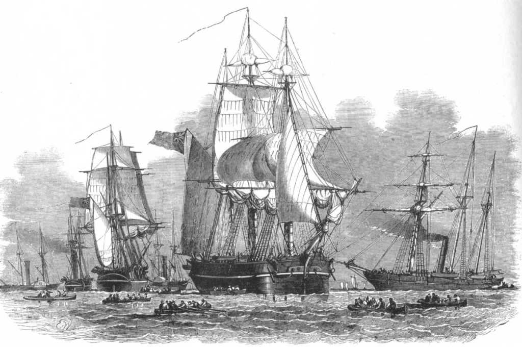
In this post I will describe the “boat place” boat at Erebus Bay that searchers looking for the lost Sir John Franklin 1845 Expedition came across in 1859. A later post will show my effort to construct a small model of this unique and sadly-fated boat, and propose some likely dimensions of the full complement of Franklin boats.

William Thomas Smith’s powerful 1895 work “They forged the last link with their lives: HMS Erebus and Terror, 1849-50.” The boat has several well-researched components, such as the washcloth around the gunwale and the ice grapnel. It also appears rigged for sailing with full masts stepped. (CC-BY-NC-ND) copyright: National Maritime Museum, Greenwich London

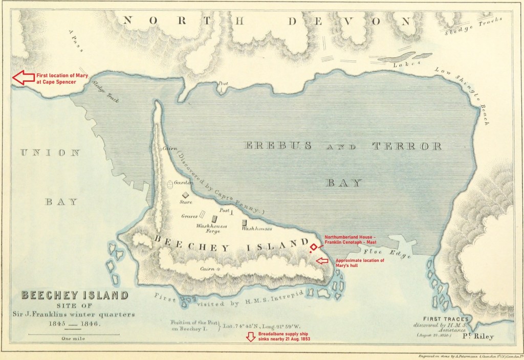
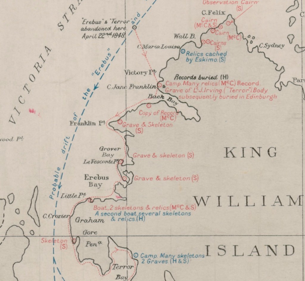
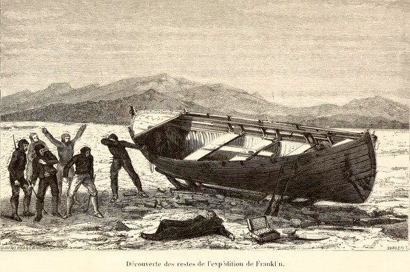
On May 23rd, 1859, at a wide bay on the frozen western shores of King William Island, a group looking for the lost Franklin Expedition found something incredible: A large boat on a sledge. Fourteen years after Franklin’s two ships had left Greenhithe, England, searchers had finally arrived at “ground zero” of the Franklin Expedition escape saga. They were a decade too late. Quartermaster Henry Toms and Carpenter’s Mate George Edwards – both members of Lt. William Hobson’s detached sledge party searching the coast as part of Francis Leopold McClintock’s Franklin search expedition – first spotted something odd projecting out of the snow as they scouted ahead of their mates.1 Closer examination revealed it to be a wooden stanchion, hanging like a beacon over the curved outlines of a gunwale in the high drifts of snow – beneath their feet was the ghostly outline of a large boat.

Chart showing the vicinity of King William Island with the various positions in which relics of the Arctic expedition under Sir John Franklin have been found / compiled by Lieut.-Cmdr. R.T. Gould, R.N [detail of]. “Boat Place” is indicated in red text at the base of Erebus Bay. Credit: Library and Archives Canada 3674742

The next morning Hobson’s group began in earnest a two-day process of clearing out the site and inventorying an unusual assortment of artifacts. That stanchion also marked a gravesite – the resting place of at least two unidentified Royal Navy crewmembers who were entombed within the hull. McClintock’s sledge team arrived a few days after Hobson had departed. His published description of what he called this “melancholy relic” is the standard account of the site.2 But Hobson had also drafted a report on his sledge team’s discoveries, which included a detailed description of the boat. We are indebted to archaeologist Dr. Douglas Stenton’s work resuscitating Hobson’s report about his journey from obscurity. Stenton’s publication of the report provides important additional details to help explore the boat place.3 Since Hobson’s team had excavated the snow from the boat and examined the objects found therein, the site had already been altered before McClintock’s party reached it. For a detailed list of the interesting and unusual contents of the boat, please see Russell Potter’s Visions of the North blog “The Boat” on the topic. My interest here remains focused on the boat itself.

This early 1860s illustration represents some of the major relics accurately, and shows the double-ended appearance and large proportions of the vessel. Credit: Durand-Brager, from Arthur Mangin, Voyages et Découvertes outre-mer au XIXe siècle, illustrations par Durand-Brager, 1863 ː Découverte des restes de l’expédition Franklin. Public domain, via Wikimedia Commons

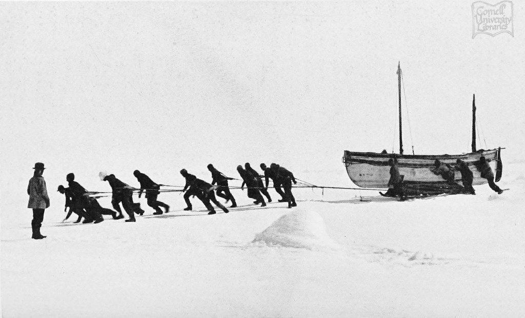
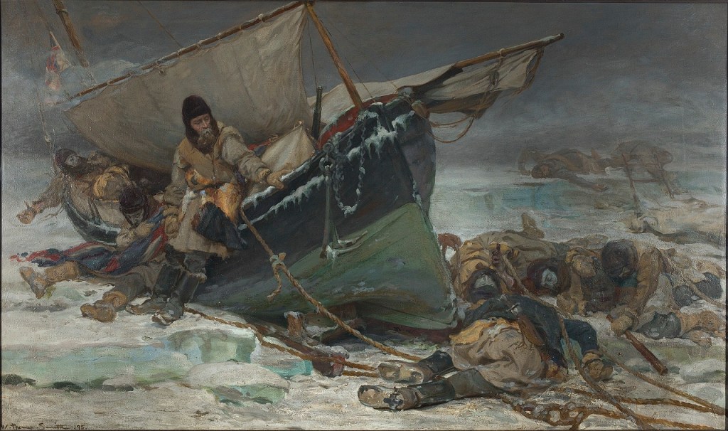
The Erebus Bay find remains the only Franklin Expedition boat and sledge, originally encountered reasonably intact, whose appearance and contents were described in detail. Its importance is tied to the slightly earlier discovery by Hobson’s party of the Victory Point record, in a sealed cylinder in a cairn about 60 km northeast. An update to a routine Admiralty form mentioned the abandonment of the long-beset ships, and recorded captains Crozier and Fitzjames’s intention to mount a desperate trek with their ailing crews towards Back’s Great Fish River. The note had no specific information about how they planned to cross the vast distances involved. The Boat Place discovery seemed to illustrate the mechanism of the evacuation plan: Crew members would use drag ropes to man-haul boat/sledge combinations down and around the coastline of King William Island. They would then unship the sledges and navigate the boats to the mainland and down a treacherous river towards a still-distant fur trading post. We don’t know how this plan changed as they struggled along, losing more men, and abandoning more boats. Some of the last of a group of weary men laid down to die, under another boat, on the mainland at Starvation Cove.

Back at Erebus Bay, the 28’/8.5 m boat was found just above the frozen shoreline. It listed dramatically down to starboard. A hole may have allowed wildlife – bears or scavenging foxes – access on the low side. Both boat and heavy sledge were oriented back towards the northeast, though if that was by intent (to return towards the ships), or by happenstance, no one can say. McClintock commented on both the boat’s lightness, and the sledge’s weight. He estimated the weight of the boat to be about 700-800 lbs while the sledge could have been as much as 650 lbs (the average weight of a 28-foot whaling boat, by contrast, was about 1,000 lbs).4 His observations were informed by his great expertise in sledging, acquired during his participation on this and earlier expeditions.

A remarkable 3D interpretation of “Boat Place.” This well-researched depiction of the boat and sledge is a recent and valuable addition to the artistic reconstructions of Erebus Bay. It was inspired by Matthew Betts’ reconstruction (see notes). The outlines of one of the ships in the distance heightens the pathos of this bleak scene. Certainly, the ships did transit by the Bay at some point after April 1848. Used with written permission of Case Western, who maintains a site with 3D printing models.

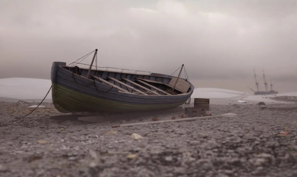
The boat had been modified by the ships’ carpenters – the square transom at the stern had been removed and the boat was now pointed or “sharp” at both ends, with a curving stem and sternpost, like a broader, deeper version of the two ships’ whale boats. The “carvel” planking (flush-edge-to-edge) of the top strakes of the hull had been replaced and lighter fir “clinker” planks (overlapping) re-laid in their place. An ingenious washcloth design of canvas was fitted in the place of the heavier washstrake boards. The set of six paddles – cut-down oars converted with larger “add-on” blades – indicate that the boat had been converted for inland/river navigation.

The stem, as drawn by McClintock in his 1859 edition of The voyage of the ‘Fox’ in the Arctic seas: A narrative of the discovery of the fate of Sir John Franklin and his companions (P 292) see notes section for link.

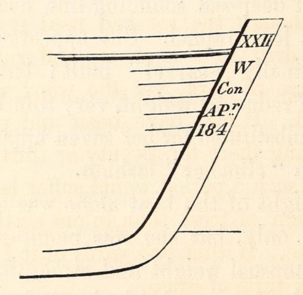
The distinctive stem of the boat was sketched by McClintock. This was recovered two decades later by American Franklin searcher Frederick Schwatka, who, while looking for records, was leading the first expedition on King William Island that encountered the sites in the summer, not under cover of snow and ice.

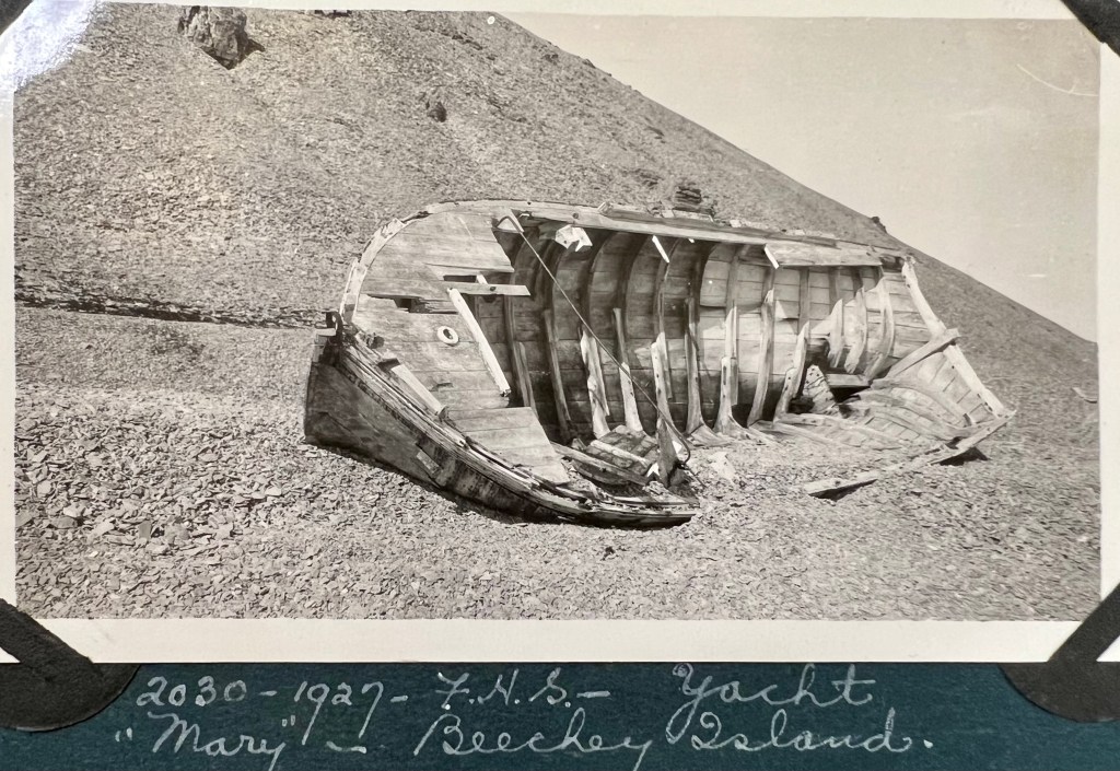
According to Inuit oral testimony, there was at least one other abandoned boat with many more skeletal remains that was located nearby.5 Both boats were dismantled in the early 1860s for their useful materials and fittings. Following the initial recovery of some artifacts, the dismantling, and Schwatka’s later removals, only archaeological traces and a memorial with bone fragments remain at the site – the last vestiges of a melancholy relic.

Another famous boat/sledge with a less tragic outcome, the James Caird, originally one of Sir Ernest Shackleton’s 22.5’/6.9m boats from his exploration ship Endurance, being dragged across the sea ice in Antarctica, Dec. 1915. Credit: Frank Hurley : via wikimedia commons.
The Design Dossier and References (click here):

Oh, They’ll be No More Yachting from Beechey, me Boys!

Arctic Album #7 (trip of SS Beothic 1926-1927) Credit : Department of Indian and Northern Affairs Canada / Library and Archives Canada, Accession 1974-366 R 216 Vol. 14948.

One of the remarkable relics at Beechey Island, connected with the searches for the Sir John Franklin 1845 expedition, is a large mast which has collapsed along the beach, pointing out to Erebus and Terror Bay. This stood for years in front of the ruins of Northumberland House and a motley collection of memorials. Beechey Island is an isolated, barren place, just off the southwest coast of Devon Island, in the High Arctic, in present-day Nunavut. It had been the site of the Franklin Expedition’s first winter encampment, when HM ships Erebus and Terror had sought shelter here in 1845 and been frozen-in. In 1846, before the Bay released the ships, three members of the Expedition were buried just up the beach. The island and surroundings later became prominent as a staging base/supply depot in the expeditions sent to try and ascertain the fate of Franklin and his crews. More searchers would die at and around Beechey, and the Breadalbane supply ship would be wrecked nearby in 1853. Today, burials, monuments, ruins and shipwrecks remain.

Beechey’s Erebus Harbour as it appeared in 1903. The Belcher Column and Bellot monument is at left (Painted black here but later white, with Lady Franklin’s white marble plaque on the ground), with the ruins of Northumberland House and an erect mast standing nearest Erebus and Terror Bay. Credit: Albert Peter Low collection at the Canadian Museum of History, CC BY-SA 4.0 https://creativecommons.org/licenses/by-sa/4.0, via Wikimedia Commons

The mast is a significant artifact with an important story.1 It is reputed to be the last large remnant of the Mary, Sir John Ross’s yacht. This trim little 12-ton cutter-rigged craft had been brought North by Ross, and accompanied his much larger yacht, the brig Felix. It had been built for the trip out, and both it and 70-foot, 100-ton Felix (sometimes referred to as a brig, sometimes a schooner) were reinforced for polar service with strong hulls and iron or zinc hull sheathing. Felix was Ross’s search ship, but Mary was intended for a different purpose.

In August 1850, Sir Horatio Austin’s crews of HMS Resolute and Assistance (accompanied by HM Steamships Pioneer and Intrepid) and Captain William Penny’s ships Lady Franklin and Sophia made exciting discoveries at and around Beechey Island.2 These first traces of the lost expedition invigorated search efforts.

The heavies form up! “Captain Austin’s Arctic Expedition; HMS Resolute and squadron.” Illustrated London News 11 May 1850. Credit: Edwin Weedon, Public domain, via Wikimedia Commons

Ross arrived days later in Felix, honouring a promise he had made to come to the aid of Franklin. He was 72 years old, and his sense of duty and concern for his friend brought him out of retirement. When the Admiralty declined his offer to lead an expedition, the Hudson’s Bay Company funded the expedition. His plan, should the lost expedition not be located or turn up, was to leave Mary behind.

Map of the 1845-46 Franklin Expedition sites, and a record of their discovery[annotated with approximate locations of some sites mentioned in this post] The British Library, “Papers and Despatches relating to the Arctic Searching Expeditions of 1850-51. Together with a few remarks as to the probable course pursued by Sir John Franklin, etc. [Compiled by James Mangles. With maps.(London: 1851)] No restrictions, via Wikimedia Commons

Ross knew better than anyone the value of a cache of food and stores and a serviceable boat. On his 1829 expedition, accompanied by his nephew James Clark Ross, his ship Victory had been trapped in ice. Three years later they were forced to abandon their refuge. They retreated to Fury Beach, where they had to spend yet another long, dark winter frozen-in. But Fury Beach was their salvation: Parry’s 1825 expedition had left a cache of supplies and three boats from their wrecked ship, HMS Fury. The boats and supplies allowed an expedition, which had been widely assumed to have ended in death and disaster, to escape to Prince Regent Inlet and rescue. Ross hoped that some similar depot and boat could help Franklin Expedition survivors, or anyone else trapped in the area.

Edward F. Finden’s engraving (John Tallis & Co) of John Ross’s crew, sailing in some of HMS Fury’s old boats, encountering the whaling ship Isabella, his old ship, in 1833 after four years. Ross hoped that Mary would be involved in a similar mission. PAD6090 Courtesy of the National Maritime Museum.

With larger Admiralty-supported expeditions scouring the Arctic, it was time for Ross to return home. Mary was initially left west of Beechey at Cape Spencer, packed with a good store of provisions. The boat was moved soon after to Erebus Harbour when the Edward Belcher expedition incorporated it into new construction. The crew of HMS North Star, the depot ship supplying the Belcher search ships, dragged Mary up the beach and deposited her under Beechey’s soaring cliffs. The yacht was intended as a companion to Northumberland House, which was packed with useful supplies and provisions. Stranded crews that came to Beechey, once they had sheltered and replenished their stocks, could strike off in the yacht in the very short navigation season that those high latitudes allow. Mary and Northumberland House functioned together as their own extraordinarily remote lifesaving establishment. Robert McClure informed the crew of his long-trapped ship, HMS Investigator, that one group would travel to Cape Spencer to board Mary.3 As every one of the Belcher search ships would later need to be abandoned, with their crews completing harrowing marches to safety, the idea had merit.

In 1876, Allen Young, on his second Arctic expedition in the retired gunboat Pandora, found Mary to be in very good shape, still tight and dry and with mast up and sails stowed onboard, in a mostly dry cabin.4 Northumberland House, by comparison, had been damaged and ransacked (reportedly by bears). Young had been one of the last to see this same spot from the Fox, as the navigator on the Capt. Francis Leopold McClintock’s 1858 expedition. With the Pandora’s departure, Mary was again left to her lonely fate.

Mary as the yacht appeared in 1876, still substantially intact. The placement appears to have been up the beach from most of the sites, closer to Cape Riley. Credit: Allen Young “Cruise of the Pandora” (London, 1876) Page 41. Public domain via Library and Archives Canada 1984-109 NPC

Occasional visits by notable Arctic explorers continued into the 20th Century. Mary sustained more damage and deterioration and at some point the mast was taken from near the hull and erected in front of Northumberland House, near a large whaling boat.5 The hull assumed a prominent list, and the decking deteriorated. Visitors also speeded deterioration by taking a few choice souvenirs. The derelict vessel was photographed in 1923 and 1927, during annual trips to the Arctic by Canadian government ships.

Inspector C.E. Wilcox and Mrs. Craig standing in the remains of the yacht Mary, 1923. Credit: John Davidson Craig / Canada. Dept. of Indian and Northern Affairs / Library and Archives Canada / PA-186867 Arctic Album #5, trip of CGS Arctic 1923 R 216 Vol. 14946.

During the 1970s and 80s, the mast leaned at an increasingly rakish angle, until it fell to the ground sometime before 1992. Like everything else at Beechey, the mast is undergoing a very gradual deterioration. We conclude our brief account of a yacht that was intended to serve as a rescue vessel with an important takeaway: If you plan to be shipwrecked in the high latitudes of the Canadian Arctic somewhere around Beechey Island, you can no longer depend on Mary to yacht away from it!

  1. Season Osborne’s detailed history of Mary “What Happened to the Mary? A Historic Site ravaged through time” (Above and Beyond – Canada’s Arctic Journal 2015/2 pp. 23-27) helped sort out many contradictions. It is available at https://issuu.com/arctic_journal/docs/above_n_beyond_marchapril_2015/ ↩︎
  2. This is a simplified account of discoveries, for a more fulsome treatment of the moment of the first discoveries at Cape Riley (by Capt. Ommanney of HMS Assistance) and Capt. Penny’s team, including R.A. Goodsir, finding the graves at Beechey, please see Alison Freebairn’s finger-post blog and Logan Zachary’s Illuminator blog on the topic. ↩︎
  3. George F. McDougall “The Eventful Voyage of H.M. discovery ship “Resolute”…(London: Longman et. al. 1857) P216. McClure ended up encountering the HMS Resolute party sent to look for him under Lt. Pim and evacuating everyone to Resolute). Available at Babel.hathitrust. ↩︎
  4. The above source refers to the mast as having been moved sometime around the Second World War, but the 1903 photo seems to show a similar mast in front of Northumberland House, which is more substantial than the flag pole that had been on the site during the 1870s. ↩︎
  5. This section is drawn from Lt. Allen Young’s Cruise of the Pandora; from the private journal kept by Allen Young commander of the expedition (1876; republished by Cambridge University Press 2012). The illustrations are from a copy of the original at Library and Archives Canada. ↩︎